

Africa’s Amazing Secret Trek | Miss the Kilimanjaro CrowdsT
The Rwenzori trek is one of the top ten “best things” to do in East Africa. The Rwenzori Mountains, are also called the Mountains of the Moon. But they are not so much moon-like — rather they have a dizzying array of spectacular plants, trees, animals, and varied landscapes that make you aware, at all times, that you are in a place like no other on the planet. And of course, you can stand on a glacier at over 5000m (16,000 ft) with world class views of Africa below you.
Why do the Rwenzori Mountains of the Moon Trek?
The Rwenzori Mountains are the highest mountain range in Africa and have the third-highest peak (Mt. Stanley, 5109m). They contain a vast array of plants, animals, and birds. Six different climate zones were traversed during our trek in November 2017 over the course of eight days climbing to the top of Mt. Stanley (called Margherita Peak). Forest Elephants, leopards, giant forest hog, deer including endangered Rwenzori black-fronted or red duiker, a number of primates such as blue monkeys, Angola colobus monkey, black-and-white colobus, l’Hoest’s monkeys, and Chimpanzees. And some beautiful and very rare birds. You also see tropical rainforests, waterfalls, and other incredible and unique flora, culminating in a high alpine environment like the Andes or Himalayas. Bottom line, this trek is not to be missed for its stunning beauty and astounding array of habitats and ecosystems. There’s something to delight everyone!
Skip the Kilimanjaro Crowds!
When hikers think of a great African hike, Mt. Kilimanjaro is most likely the first option that comes to mind. As a result, the Rwenzori mountains remain fairly under trekked. At one point, the guides told me they now average about 1,000 people a year hiking this trail which is a fraction of the 35,000 people a year that attempt Mt. Kilimanjaro.
Essential Info for the Rwenzori Mountains of the Moon Trek
Duration | The trek to summit Mt Stanley takes eight very full days.
Best Time of Year | Late December until mid-March and from mid-June to mid-August is the “dry season” although you will likely still see some rain as well as some potential mist & fog obscuring your views. These dates lower your percentage chance of rain and in this muddy climate, all non-rainy days are highly desirable.
Technical Difficulty | This can be a technical or non-technical trip, depending if you summit Mt. Stanley or not. Those that choose to summit will be fully roped and using crampons and ice axes to traverse technical rock and ice. There is a non-technical version of the trek!
Physical Difficulty | This is a strenuous trek. You start at 1450 meters (~5,000 ft) and climb to over 5,000 m (Mt. Stanley summit, 5109m) or around 17,000 ft. Even fit hikers may be challenged by steep ascents on very muddy trails. And everyone, fit or not, has the possibility of difficulty with altitude acclimatization.
Location of Trek | Margherita Hotel in Kasesse Uganda
Getting There | There are daily flights on Aerolink Uganda from Entebbe to Kasese, including a morning flight that allows you to start your hike that same morning if you are short on time. Most people, however, spent the night in Kasese and were fresh to go the next morning.
Accommodation | You will stay in mountain huts each night
Guiding | A guide is required to do this trek. There is no self-guided option. We used Rwenzori Trekking Services and highly recommend them.
Packing List | You’ll need a broad range of clothing and gear for the vast array of conditions you’ll encounter — from wet/muddy tropical rainforest to high alpine glaciers. If you choose to summit, you’ll also need, at a minimum to bring your own crampons (the guiding company will provide the rest of the technical rock and ice gear, but you may wish to bring your own technical gear like harness, ice axes, helmet, etc.)
In stark contrast to the high alpine environment of the preceding photo, the Mountains of the Moon Trek starts in lush tropical rainforest and is famous for its waterfalls.
What You Need to Know
Gear
It is critical to have the right gear on this trek. The trek starts in hot, low-altitude tropical rainforest with mud and accompanying insects with their potential for tropical diseases. And if you choose to summit, it culminates in high alpine glaciers and technical ice and rocks at over 5000m (16,000 ft) with the wind, sleet, and snow. As such, you’ll need clothing and equipment to handle an exceptionally broad range of conditions. [For those who do not want to summit, there are shorter trips available where you can still experience the beauty of the Rwenzori Mountains without ice axes and technical terrain.]
A Few Key Pieces of Gear
Trekking Poles | An absolute must for the muddy, slippery, and treacherous trails. Also essential for the drier alpine sections of the route. Don’t leave home without them! We like Cascade Mountain Tech Carbon Fiber Trekking Poles for their low cost while still competing with the most expensive carbon fiber mountaineering trekking poles.
Rubber Boots | While very few (if any hikers) train in rubber boots, they are a must for this hike. Even in the dry season, the mud is often up to your knees, which means you need to assess every rubber-booted step carefully. The trail necessitates climbing steep ascents and descents in these same rubber boots, so not only do you need them, but you need to be comfortable enough in them to spend most of every day hiking in them. Rubber Boot Tip: bring your own shoe liners and an array of socks to fine-tune the fit of the provided boots. It makes a huge difference!

Technical Gear
The following boots and crampons for technical portions of the trek will save you a bunch of weight (kilos of weight!) and be a lot more comfortable than huge mountaineering boots and heavy-duty, ice-climbing crampons. This will save you energy and effort, as climbing above 5,000 m is rough for everyone! Every gram counts.
hiking boots (for use with crampons)
Crampons
Note that Rwenzori Trekking will provide all technical gear except for crampons and your climbing boots
You’ll stay each night in Mountain Huts. Pictured is the Margarita Camp, the base used to summit Margarita Peak

What You Need to Know About Rwenzori Mountains Trek
Guides and Guiding
We understand that some hikers do not like to take either a guide or a porter. In that case, this is not the hike for you. Because it is a UNESCO World Heritage site, and the Government of Uganda carefully protects it, there is no way to climb Mt. Stanley without a guide. We used Rwenzori Trekking Services (RTS) for our trek and strongly recommended their use. They have excellent equipment, and the guides are well-trained in mountaineering. We felt completely safe at all times.
Our guide looks toward our next camp. Because it is a UNESCO World Heritage site, and the Government of Uganda carefully protects it, there is no way to climb Mt. Stanley without a guide.
Porters
While you are welcome to carry your own gear, the local porters stand ready to help, and your money goes directly into an economy that not only relies on it but secondarily encourages the conservation of the land. In other words, think of the guides and porters as your way to positively contribute to a sub-Saharan economy while encouraging the preservation of this world-class resource. Finally, if you do not hire a porter, know that porters will still be part of your trekking team. While each of the eight of us hired one porter, our entire team of porters numbered 24. These extra porters brought food from hut to hut along with cooking supplies, utensils, toilet paper, etc.
Physical Challenge | Strenuous
This hike is strenuous. Every single day. Day one of this trek includes an ascent of 1146 meters (3,760 feet) while day four goes up and over Bamwanjara pass, 500 meters (1,640 feet) ascend/descend, in rubber boots over very steep terrain (which, as an aside, you do a second time on your return, the day after summitting). Add to all of this the extreme changes in elevation in a very few days and altitude sickness can be a real challenge. We started with eight in our party (all experienced mountaineers) and in the end, only three people summitted Margherita Peak.
Climate Change Makes the Trek More Difficult
Serious erosion of the glaciers from climate change has made summitting Mt. Stanley much more technical than in the past. Crampons need to be taken on and off at several erosion points, and the use of ice axes, harnesses, and ropes is required. Even then, the conditions are tricky as you maneuver across the rocky, icy craggy shelves to the top — and receding glaciers have left behind a lot of loose, unconsolidated rock, which is unstable and dangerous.
Optional Non-Technical Trip
For those who do not want to undertake all that is involved to reach the summit, there is good news. There are shorter trips available where you can still experience the beauty of the Rwenzori Mountains without ice axes and technical terrain. Mind you, day one will still require climbing 1146 meters (3,760 feet), and you will still be required to wear rubber boots almost every hour of every day. But you will have more time to enjoy the walk and, overall, stay at a lower altitude.
One of the newer huts, RTS is in the process of redoing all huts to look something like this (altho some older huts are not as nice as this (for now!).
Water, Food, Huts, Toilets, Etc.
Since this is a guided trek, the guides and porters cook breakfast and dinner and provide a sack lunch for the hike. The guides do try to be mindful of special dietary requirements. We found the food to be adequate and very few of us got sick (at least from the food).
Water | is plentiful the entire trip, and the guides boil water before using it. We filled water bottles at the beginning of every day (with boiled water). For extra assurance, feel free to bring water treatment with you.
Mountain Huts | are basic with bunk beds housing between 4-8 people per hut. In a few camps, there were huts with 1-3 beds for other parties or if someone needed to be alone (i.e. sick). You will sleep inside every night, on a bed (bring your own sleeping bag and earplugs).
Toilets | Each camp has at least two privies. They will be squat toilets where you do your business and then slosh water over the privy. Overall, they are kept clean, and you quickly get used to them.
Washing Up | A standard Ugandan offering is a water jug with a bar of soap on top. Every camp had one outside of our sleeping area, so you could always wash your hands and/or face while in camp. They usually would fill it with boiling water, so if you went at the right time, hot water was waiting for you.
Safety
We had no safety concerns during the entirety of our trek. The Rwenzori Mountains sit on the border of Uganda and the Democratic Republic of Congo. We had heard rumors of gun-toting guards needing to protect clients, but none of that turned out to be true. The Rwenzori rangers carried the only guns we saw during our hike, not our guides. And the rangers only carry guns to deter poachers. We only saw the rangers on patrol once, and they were quite friendly.
Gear | Packing List
The gear you bring is crucial to the success of this hike. In addition, because you are sleeping in a hut and being fed by the trekking company, there is no need for a shelter or cooking system. Mostly, you will need to bring the right clothes and footwear for your trek. The only additional item required will be a sleeping bag. See the list of gear we brought on the trek below.
Quick Overview of the Trek
We took eight days to summit Mt. Stanley. While there is a 7-day option available, you need to not only be ready for even greater altitude change in a shorter time, but you will miss one full day of being in the Rwenzori Mountains. Also, it is worth considering your trekking speed in rubber boots on very muddy trails. You will need to move with extra speed for a 7-day trek.
If you choose Rwenzori Trekking Services (RTS), you will follow the Kilembe trail. Each of the two services use different trails and different huts, so you will not interact with anyone who is not trekking with RTS.
Day by Day Itinerary for the Rwenzori Mountain Trek
Day 1 : (1146 m/3,670 ft ascend): Meeting at the old hostel to check gear, get rubber boots, review the map, get a porter, meet your guides, and head out. We used the rubber boots offered by the RTS and found them perfectly adequate and spent most of the next 8 days in those same boots. The rest of our trekking party purchased and brought their own rubber boots for use.
The first 2km of the trek is essentially walking up a washed-out road until reaching the park entrance. Guides mentioned that RTS is thinking about moving their hostel to the park entrance to eliminate this community walk, and we have to agree that it would enhance the overall trek. It is also the first few hundred meters of your day one 1136-meter ascent (3,760 feet) and takes 30-40 minutes.
-There is an entrance fee of $35/night, payable in dollars, shillings, or by credit card. If you decide to pay with dollars, make sure you have new, crisp bills with no marks or tears on them. Once paid, we entered the park and headed up steeply for the remaining ascent. The lunch stop has an overhang and a privy and marks the end of the 1136-meter ascent. From there, it is a fairly level 30-minute walk to Sine Camp. Sine Camp is known for its beautiful waterfall that provides a welcome shower after an intense hot day through the tropical rainforest.
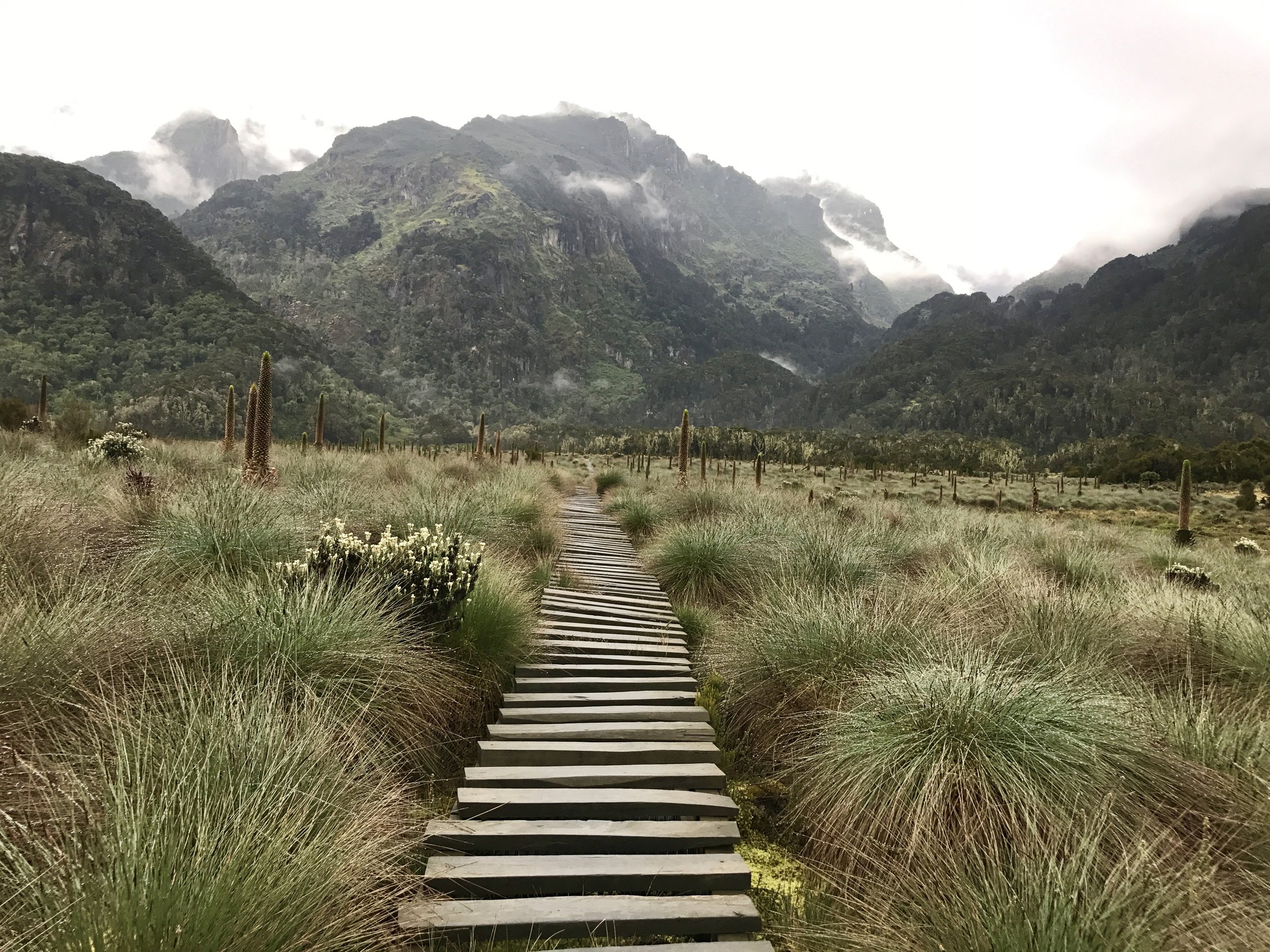
Day 2 - Nyabitaba Hut 8694ft/2650 m: Walking out of the tropical rainforest provides some cooler relief, and this day we moved from the tropical rainforest to Bamboo Forest and into the Heather Zone. Monkeys live in the Bamboo Forest, and we were able to get pictures of several species of monkeys. In the morning, there is a beautiful ridge traverse, and it is also on Day 2 where we broke free of the rainforest and started to see some of the expansive Rwenzori flora and fauna. We also were introduced to boardwalks and ladders encountered during the rest of the trek. The trail follows the Mubuku River, crossing its Mahoma tributary before starting a long, steep climb up onto the massive ridge to reach the Nyabitaba Hut. During this part of the trip, you may hear chimpanzee and see black and white colobus monkeys, blue monkeys and the brilliantly colored Rwenzori turaco. Dinner and overnight at the Nyabitaba Hut set on the forested ridge with a view of portal peaks and the Bujuku Valley.
Day 3 - John Matte Hut (11089ft/3380 m: This is the first mandatory rubber boot day. Day 2 may require rubber boots depending on the amount of rain, but on Day 3, no options are offered (only rubber boots). Early breakfast, then we start the hike to the John Matte Hut. The trail descends through forest to cross the Bujuku River at the Kurt Shaffer Bridge, and through a lobelia, giant heather and groundsel forest. You will stop at Nyamileju Hut, “Place of Beards,” a name that refers to the moss and lichen hanging from the trees. Mount Stanley and Mount Speke can be seen before passing into the forest. You will carry on to the John matte Hut, which is close to the river in a grove of giant heather. Dinner and overnight at John Matte Hut.

Day 4 - Bujuku Hut (13,047 ft/3977m): From John Matt hut, the trail drops down to cross the Bujuku River and enters Lower Bigo Bog, the home of giant lobelia. Jumping from tussock to tussock, the bog is finally crossed, but rarely without the your feet sampling some of the freezing ooze below. The Bupper Bigo Bog gives way to Bujuku Lake, with views of Mount Baker to the south and Mount Stanley to the west. Bujuku Hut, well located in the shadow of Mount Baker and Mount Speke, is set in a narrow valley below Stuhlmann Pass. Dinner and overnight at Bujuku Hut.
Day 5- Mount Speke (16,024 ft/4890m) It’s an early start today .This will be a long day up one of the main peaks of the range. Snow may be encountered and lots of easy rock scrambling. Trekkers can have a more leisurely day relaxing and exploring the area. After standing on the summit, climbers return to the Bujuku Hut for the night.
Day 6- Elena Hut (14,898ft/4541m) Leaving Bujuku, the trail takes you through more bog, while climbing the steep slopes west of the lake and through the magical Groundsel Gulley as it ascends to Scott-Elliot Pass at 14,343 feet / 4372 meters. At the head of the gully, a metal ladder takes you over a steep section after which the trail is divided into two. The trail on your right leads up to Elena Hut and Mount Stanley on a steep trail over large boulders, while the trail on your left leads to Scott-Elliot Pass and down to Kitandara Lakes. The trail on the left leads those who are not climbing Margherita Peak down to Kitandara Hut. Dinner and overnight at the cool and icy Elena Hut.
Day 7 -Margherita Peak (16,761ft/5109m) For those aiming at reaching Margherita Peak and Albert in the same day, continue to the base of Stanley Glacier. To reach the summit of Margherita, the climb takes about 5 – 7 hours depending on the weather conditions and the pace of the group. This tough walk takes you over three glaciers, slippery rock, ice and some exposed areas. The route gets us up on the glaciers to cross the Stanley Plateau. After standing on the summit of Margherita, the highest peak in the Rwenzoris, we come back to the Elena Hut for lunch and then proceed down to the Kitandara Hut at 13,211 feet / 4027 meters.
Day 8: Mount Baker/Freshfield Pass ( 15,892ft/4844m)
You will trek to Freshfield Pass today. From Kitandara, take the trail that ascends steeply up the headwall, spreading out from the base of Mount Baker and continuing along the south side of the mountain to Freshfield pass. At this point, you will have views into the Congo to the west and Mount Stanley to the north. From the pass, trekkers will take the long trail passing the rock shelter at Bujongolo, the base camp for the historic expedition by the Duke of Abruzzi in 1906. Climbers will get an earlier start and climb the mountain from the pass. Celebration dinner with the porters and overnight at Guy Yeoman Hut. (It is recommended that tips be given this night).
Day 9: KASESE Elevation: 11,319 ft / 3450 m
We wake up early and descend from Guy Yeoman to Nyabitaba Hut and then to Nyakalengija. Below Guy Yeoman, the route descends the cliffs of Kichuchu. Beyond Kichuchu, the muddy path crosses the Mubuku River twice before climbing upwards to Nyabitaba to complete the circuit and continue to the park gate. Overnight in Kasese.
Protect Rare, Pristine Environments | Support Local Communities
Past Two Years in the Rwenzoris
In 2020, the city of Kasese, at the base of the Rwenzoris, experienced one of the worst flooding incidents ever. The flood swept away homes and schools, submerged farms, cut off bridges, and left several roads inaccessible, affecting 24,760 houses and an estimated 173,000 people. The Kilembe trek did not escape the wrath of the floods, and large swaths of the trek had to be rebuilt. In fact, since May 2020, when the flood occurred, the porters and guides who work on the mountain have rebuilt a new 22 km of trails. Tourism from trekking is estimated to support over 1,000 community members.
When the floods are combined with the onset of the COVID shutdowns, the past two years have been especially difficult for the communities surrounding the Rwenzori Mountains. As tourism faltered, the community members turned to poaching as a way to survive. In turn, UNESCO provided an emergency grant for the development of a disaster and risk management plan. Recently, tourism has begun to return, although as much reduced levels. Estimates are 1,000 tourists currently visiting the mountains, down from approximately 5,000 a year in 2018.
The bottom line is your trekking in the Rwenzoris is a win-win. You have a fantastic world-class trek, and the environment and local communities benefit as well!
Detailed Map of the Rwenzori Mountain Trek

The Rwenzoris, a UNESCO World Heritage Site, comprises 16 mountains, including five of the 10 highest peaks in Africa. Lining the Ugandan border with the Democratic Republic of Congo, the range also straddles the equator. “Nowhere else in the world can you see beautiful snow-capped mountains right on the equator,”
The Rwenzoris see just 6 per cent of the footfall that Kilimanjaro does. “They are so little visited, you can trek and not see another person,”
More support is needed to aid the efforts to protect the area. “The biggest pressures on the mountains are tree felling and climate change, which some predict will mean the glaciers may only last another 10-15 years.”
There are many communities living close to the national park that could benefit from increased tourism to the area.


Despite all the instabilities, difficulties and major fatigue it was by far the most fantastic trip I have even taken. Thank you to 7SummitsAfrica and my dear friend Carel and Sally .