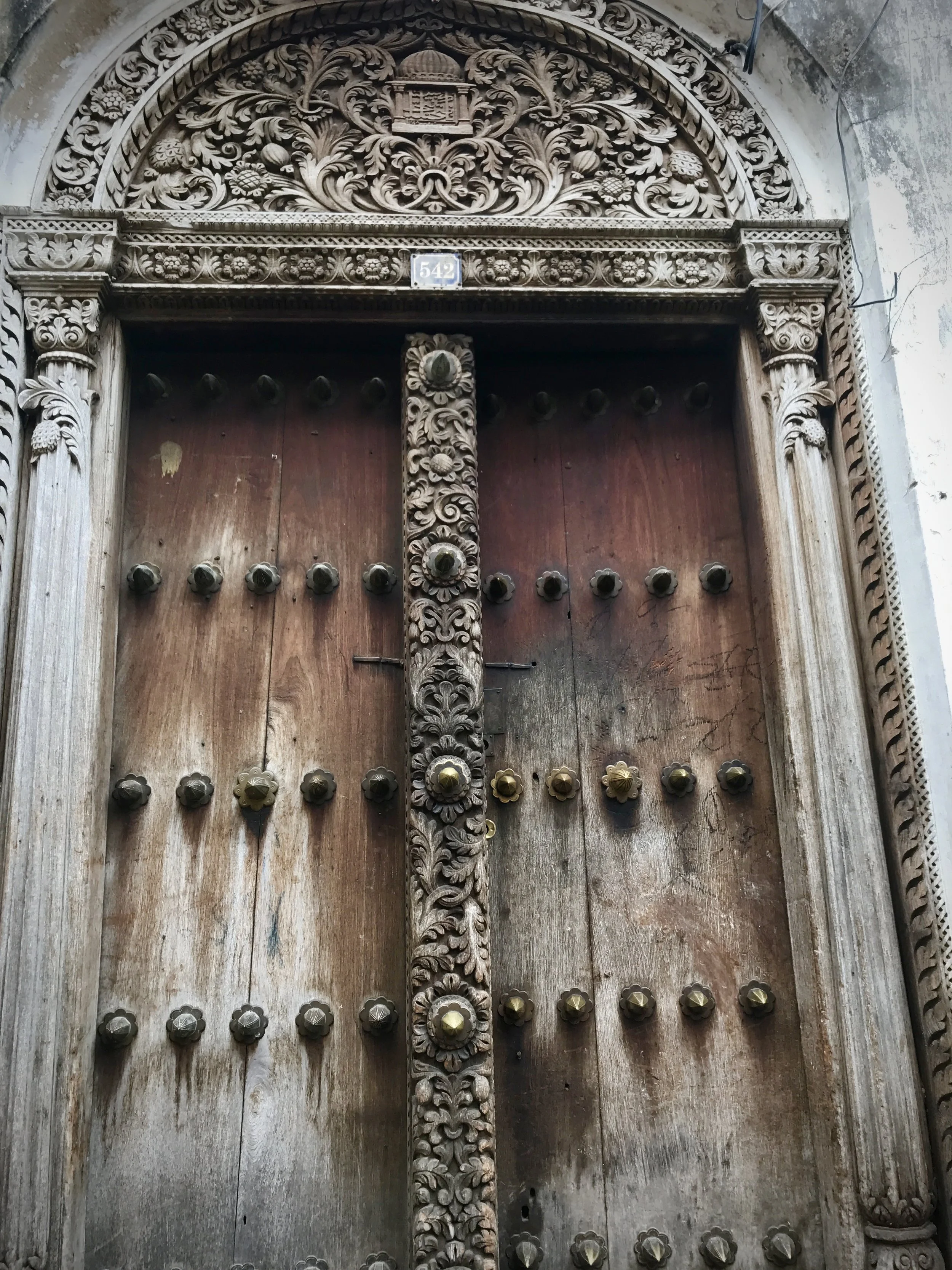
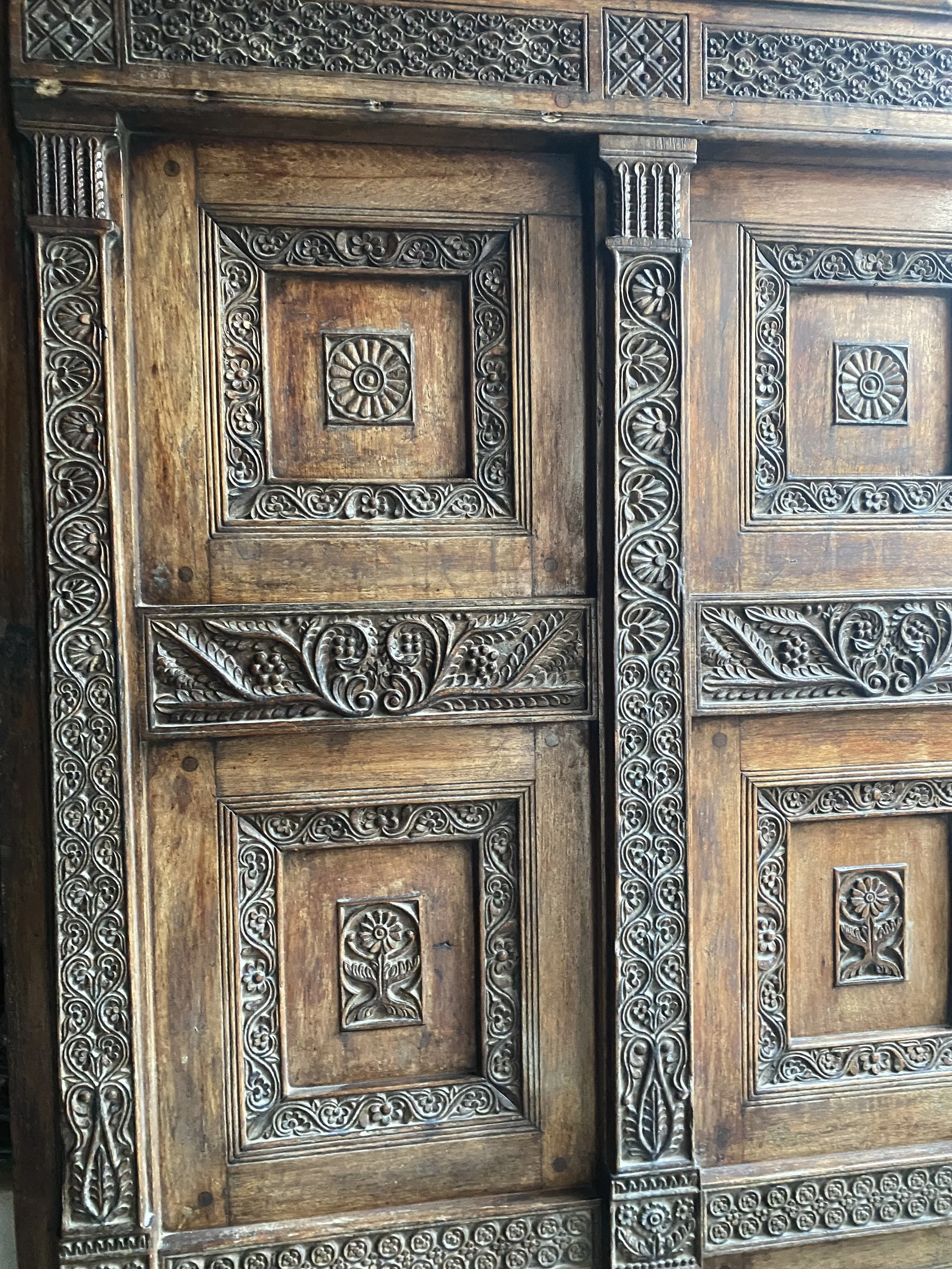
AMMAN'S CITADEL, MORE THAN AN ARCHAEOLOGICAL SITE

AMMAN'S CITADEL, MORE THAN AN ARCHAEOLOGICAL SITE

(Photo credit: Visit Jordan) 

The Citadel Amman

The Citadel in Amman was used even before the Romans arrived, with evidence of a Bronze Age settlement (about 3,000 - 2,000 BC) before Marcus Aurelius built the Roman Temple of Hercules (which is the two pillars that are the focal point of the Citadel).

The ruins are really interesting to explore and take in that this place was built over 4,000 years ago. It always blows me away that ancient civilisations could build incredible structures like the Temple of Hercules.

Rising from one of Amman’s seven historic hills, the famed Jabal Al-Qal’a (the Amman Citadel) stands as a living testament to the city’s seemingly infinite history. This L-shaped hill in the heart of Jordan’s capital has witnessed the rise and fall of several civilizations over the millennia –each leaving its mark on this sacred ground. Today, the Citadel is an archaeological marvel and a symbol of cultural and religious diversity, where the echoes of ancient beliefs and customs meet contemporary pilgrims and travelers.

The history of the Citadel goes all the way back to the Neolithic, with evidence of continuous human habitation dating back to 1800 BCE. As the capital of the ancient Kingdom of Ammon, known as “Rabbah” or “Rabbath Ammon,” the hill served as an important political and religious center. Over the centuries, it fell under the influence of powerful empires: the Neo-Assyrian, Neo-Babylonian, Ptolemaic, Seleucid, Roman, Byzantine, and Umayyad. Each of these civilizations helped weave the complex, rich tapestry of the Citadel, making it one of the oldest continuously inhabited sites in the world.

Photo by Gabriele Brown

POINTS OF INTEREST

Among the Citadel’s most prominent features are the remains of three key structures, each representing a different faith that once flourished here. The Temple of Hercules, dating from the 2nd century AD, is a striking example of Roman religious architecture. Dedicated to the mythical hero Hercules, the temple is clear evidence of the Roman Empire’s influence on the region, and its typical blending local traditions with its own.

Adjacent to the Roman temple is a Byzantine church –a testament to the spread of Christianity in the region during the 3rd century. Although the church is now in ruins, its presence on the citadel underscores the hill’s importance as a spiritual center during the Byzantine era, when Christianity was the dominant faith. The Byzantines used the Roman temple as a quarry to build their own structures atop the hill.

The third significant structure is the Umayyad Palace, built in the 7th century AD. This palace complex, which includes a mosque, is an example of early Islamic architecture, with a design heavily influenced by Byzantine architecture. The mosque within the palace is particularly noteworthy as an early example of the Persian-style apadana hall, a design typically found in Persia and Mesopotamia. This blend of styles reflects the cultural and religious syncretism that characterized the Umayyad period.

The coexistence of these three religious structures within the walls of the citadel is a powerful symbol of the site’s role as a crossroad of faiths and traditions. Paganism, Christianity, and Islam all found a place here, creating a palimpsest of beliefs that continues to resonate through the ages. Even today, visitors to the Citadel can sense the layers of history that have shaped Amman into the vibrant and diverse city that it is.

More than just an archaeological site, the Amman Citadel is a sacred space where history, culture and religion converge. As you walk among the ruins, you are walking through the remnants of the past, where different traditions once thrived side by side and continue to coexist. This unique aspect of the Citadel makes it an essential destination for anyone seeking to understand Jordan’s rich cultural heritage and the enduring legacy of Amman’s ancient hilltop.

by Daniel Esparza is currently an associate professor of communication ethics and aesthetics at the Ramon Llull University in Barcelona.

Wadi Rum (Arabic: وادي رم ) , Valley of the Moon

Wadi Rum (Arabic: وادي رم ) , Valley of the Moon

I had heard the desert held a certain magic, but it wasn’t until I went there myself that I understood what people meant by that. Wadi Rum is a place that echoes with laughter by day and where you hear the void of the desert by night. It’s a place that matts your hair and stains your cheeks orange with dirt, but leaves you overwhelmingly happy at the end of the day. It’s a place where the earth glows red under the sun, and where you can gaze up the cylindrical spheres that twinkle in the midnight sky. It’s a place that T.E. Lawrence (better known as Lawrence of Arabia) described in his notes as “vast, echoing and God-like”, and it’s a place that I hope I can one day return to.

With scarves wrapped around our heads and sunglasses to shield our eyes from the sand, we hopped in the back of a Toyota pick-up truck and began our journey into “The Valley of the Moon”. Our first few days in Jordan had been spentexploring the ancient Greco-Roman ruins of Jerash, communing with nature in the Dana Nature Reserve, and reaching the Lost City of Petra, however, this, the wild untamed desert, felt like the Jordan I had been looking for all along.

Wadi Rum (Arabic: وادي رم ) is a protected wilderness area and UNESCO World Heritage Site situated in the south of Jordan. It is set on a high plateau at the western edge of the Arabian desert. Wadi Rum is a desert valley cut into sandstone and granite mountains, featuring a varied landscape of narrow canyons, towering cliffs, natural arches, inscriptions, rock carvings and archaeological remains. Wadi Rum was an outpost for nomadic Bedouins and caravans travelling on the ancient trade route between Saudi Arabia and Petra. Wadi Rum Protected Area was established in 1997 and named a UNESCO World Heritage site in 2011.

GEOGRAPHY OF WADI RUM

Wadi Rum is the product of millions of years of geological processes. The continual uplift, tectonic faulting, weathering and erosion have transformed the mountains of Wadi Rum into what we see today. Since early times, the natural landscape of Wadi Rum was the main source of life for Bedouins and their large herds of livestock. The only year-round water source for locals was freshwater springs near the eastern face of Jebel Rum, hence the development of Wadi Rum Village. The highest elevation in Jordan is Jebel Um Ad Dami at 1,840 m high, located in the south of the Protected Area, near the border with Saudi Arabia. On a clear day from the top, it is possible to see the Saudi desert, the Red Sea and the mountain ranges of the Sinai Peninsula, Egypt. Jebel Rum and Jebel Um Ishrin are the second and third tallest peaks, located on either side of Wadi Rum Village.

HISTORY

Wadi Rum has been inhabited by many human cultures since prehistoric times, including the Nabataeans. They left their mark in the form of petroglyphs, inscriptions and archaeological remains. Petroglyphs, representing humans and animals, are engraved on boulders, stones and cliff faces. Numerous inscriptions in different North Arabian scripts, Thamudic, Nabatean, Islamic and Arabic, evidence of an early emergence of alphabets and widespread literacy around pastoral societies in the Arabian Peninsula.

In the West, Wadi Rum is famous for its connection with British officer T.E. Lawrence, who travelled through Wadi Rum and the surrounding area several times during the Arab Revolt of 1917-18.

WADI RUM PROTECTED AREA

Wadi Rum Protected Area is a UNESCO World Heritage Site because of its remarkable natural beauty and cultural significance. The towering mountains, golden sand valleys, ancient petroglyphs and inscriptions make it stand out from the surrounding desert areas. The core history and magnificent scenery of Wadi Rum can be found within the Protected Area.

The vast Wadi Rum Desert and surrounding areas are divided by tribal land, and tribe members are responsible for running tourism activities and tours within their territory. The Zalabieh Tribe operate tours inside Wadi Rum Protected Area, based in Wadi Rum Village, the main hub of Wadi Rum. Other tribes, who have recently entered the tourism industry with the backing of Amman businessmen and building unlicensed camps, control the buffer zones, such as Disah and Shakriyyah.

THE ZALABIEH TRIBE

The Zalabieh Tribe is the prominent Bedouin community in Wadi Rum. Bedouins have a deep-rooted connection to the desert. Bedouin (Arabic: بَدْو‎) originates from the Arabic word badawī, which translates to ‘desert dwellers'. Their traditional way of life, steeped in nomadic heritage, has been preserved through the decades and passed down from generation to generation. Living in harmony with the desert, the Zalabieh Tribe embodies resilience, resourcefulness andan unmatched knowledge of the land.

The Zalabieh tribe is responsible for developing Wadi Rum into a tourist destination. They offer authentic desert experiences by organising tours, working as guides and owning camps. Many families have become semi-nomadic, embracing modernity and settling near schools and water resources, while others remain in the desert, living a nomadic lifestyle, often raising sheep, goats and camels. Bedouins lead a modest life with minimal belongings and what they need to survive in the desert and live in harmony with nature. Their culture and lifestyle make for an authentic and unforgettable desert experience.

 My Journey To Jerash From Amman, Jordan

My Journey To Jerash From Amman, Jordan

So, I’m going to be honest. I’d never heard of Jerash before I visited Jordan. I would definitely not describe myself as a history buff, but I absolutely adore archaeological ruins.

Jerash is one of the most important Roman sights in the Middle East and one of the best-preserved Roman cities outside of Italy.
Reading about this ruined city left me astounded. It was a hugely significant settlement back in the day; prime placement on King’s Highway meant that it was incredibly prosperous and had very grand architecture. This made me uneasy on the drive in; all this fascinating history, with gladiators, chariots and beautiful structures was bound to bring the crowds in droves. I’d also read that it was Jordan’s second most popular tourist attraction after Petra. None of this bodes well when you are as anti-tourist as I am.

We did not need to worry. We traveled during the conflict in Israel and Gaza, which limited the visitors to the region. The car park was empty when we arrived early in the morning. The only man present insisted we park our car right up next to the single restaurant on site


The region around Jerash has been inhabited for more than 8000 years, but the city of Jerash itself can be explicitly traced back via Greek Inscriptions to Alexander the Great, around 331 BCE. These inscriptions indicate that the city was called Gerasa, which was in honor of the first inhabitants, Alexander the Great’s retired Macedonian soldiers (Gerasmenos in Greek means aged people, so I’m told).

After the Roman conquest in 64 BCE, many more structures were built, and by the 3rd century, around 20000 people were believed to have resided in the city of Jerash. 

The Galilee earthquake around 749 CE marks the initial decline of the ancient city. The city was used as a Crusader garrison in the 12th century, then abandoned, and the entire city was hidden under sand until excavation began in 1925. Half of the ancient city is yet to be excavated. 

In the present day, the Roman ruins are surrounded by a modern Middle Eastern city, a beautiful dichotomy. 

ARCH OF HADRIAN AND THE HIPPODROME

Once you visit the city, the first sights you run into are the Arch of Hadrian and the Hippodrome. 

A VISUAL IMPRESSION: PHOTOGRAPHIC GUIDE TO JERASH, JORDAN

I won’t give you a lot of background behind the sights in this blog, however, this photographic guide of Jerash will give you a visual impression of why Jerash should be part of your trip to Jordan. 


HADRIAN'S ARCH

Towering over all who visit, this 21-metre high, intricately decorated arch - also known as the Triumphal Arch - is the gate through which you’ll enter the ancient city. Built-in 129 AD to commemorate the visit of Emperor Hadrian, it was intended to be the city gate of a new southern quarter along the road to Amman - a plan that would soon be abandoned as Jerash’s finances declined.

For this reason, the arch remains a freestanding structure, nearly 500 meters from the Southern Gate and the rest of the city.


THE HIPPODROME

As you make your way toward the South Gate, you will pass the huge hippodrome—an ancient sports field built between the first and third centuries, designed to accommodate up to 15,000 spectators.

You can find the Hippodrome here on Google Maps.

THE OVAL FORUM

After passing through the South Gate, you will reach one of Jerash’s most celebrated sites - the Oval Forum (or Oval Plaza).

Highly regarded for its form (it’s the only oval-shaped plaza in a Classical-era city), it also remains remarkably well-preserved. The many original eight-metre columns have been re-erected, not simply replaced, and the paving stones are the very same that were laid by the Romans.

You can find the Oval Forum here on Google Maps.

THE SOUTH THEATRE

Many consider the South Theatre one of Jerash’s most impressive structures, not least because of the astonishingly large amount of work that has gone into restoring it.

Built around 90AD, this huge two-story structure could seat more than 3,000 spectators and was constructed with an eye on enhanced acoustics. Thus, a single speaker in the center of the orchestra floor could be heard—without shouting—throughout the entire theatre.

You can find the South Theatre here on Google Maps.

Did You Know? Upon entering the South Theatre, you may well encounter a bagpiper or two roaming the internal walls. While this may seem a little out of place (actually, scratch that - we found it downright bizarre), there’s a good reason. Not only does it provide an excellent demonstration of the theatre’s incredible acoustics, but it’s also an example of Jordan’s bagpiper tradition that dates from the period of British colonial rule when, during the process of setting up and training the army, bagpipe bands were also created. Despite the British Mandate ending decades ago, the instrument has remained popular with Jordanian musicians even performing at the Edinburgh Tattoo!

THE CATHEDRAL COMPLEX

While the Romans were originally a polytheistic civilization, by the mid-4th century (the beginning of the Byzantine period), the city of Jerash had aistian population, the growth of which culminated in the building of the ‘Cathedral.’ significant Chr

The first church built in Jerashe's first half of the 5th century atop the Roman Temple of Dionysus (the ornately carved gateway through which you enter the complex itself) was built in th.

You can find the Cathedral here on Google Maps.

CARDO MAXIMUS

Also known as the ‘Colonnaded Street of Jerash’, this wide paved street runs 800 meters from the Oval Forum to the North Gate; an arrow-straight Roman road lined by millennia-old columns and still paved with original stones, it draws a line straight through the heart of the ancient city.

NYMPHAEUM

Once you’ve explored the Cathedral Complex, you’ll continue along the Cardo Maximus to reach the Nymphaeum - a large public fountain and the best preserved in any Classical-era site in Jordan.

Built towards the end of the 2nd century, this elaborate construction was much more beautiful than it perhaps had to be, built with marble, sculpted Corinthian columns, and seven carved lions’ heads from which the water would cascade into a large pink granite basin below.

You can find the Nymphaeum here on Google Maps.

SANCTUARY OF ARTEMIS

Built in the mid to late 2nd century and dedicated to Artemis, the goddess of hunting and fertility (and the daughter of Zeus and Leo), this temple is believed to have been Jerash's largest and most important.

Visitors can enter through the propylaea, a monumental gateway reconstructed in the late 1920s by the Jordanian Department of Antiquities. They then climb the stone staircase to enter the inner temple, the altar terrace, and finally, the temple platform.

Remarkably, eleven of the twelve huge Corinthian columns that rim the temple platform remain standing and are the most impressive feature of the building.

You can find the Sanctuary of Artemis here on Google Maps.

THE NORTH THEATRE

The North Theatre may be significantly smaller than its southern counterpart, but we actually think it’s our favorite.

Even after its third-century extension, the impressive semi-circular structure, which seated just 1,500 people, was likely used for council meetings rather than public performances (a fact supported by the names of council delegates inscribed upon the stone seats) before its destruction during the 749 AD earthquake.

Having undergone painstaking reconstruction in the 1990s, the theatre has been restored to an exceptionally high standard; archeologists are confident that the building that stands today is a true reflection of the Roman creation.

Be sure to head up to the top tier of seating for fantastic views over Jerash, and even ‘tread the boards’ yourself to step back in time on the stage.

You can find the North Theatre here on Google Maps.

(Jerash is the Arabised name) has been inhabited for millennia, with evidence of occupation from as early as 7500 BC. However, it wasn’t until the Romans arrived in 63 BC that this ancient city atop a hill began flourishing, becoming part of the Roman province of Arabia in 106 AD (this province also included Amman and Petra).

Jerash reached its zenith in the late second and early third century, as road connections between the great cities in the east led to trade and taxation, wealth and expansion (both in population and construction); in 129 AD, Emperor Hadrian - yep, he of the UK wall fame - even sojourned here for an entire year.

Alas, as is often the case in this once great metropolis, Jerash began a slow slip into anonymity in the several centuries that followed, as trade routes that had once been so profitable were eschewed for ships that sailed the sea. Invaded by the Persians in 615 AD and conquered by Muslim forces in 636 AD, it was a devastating earthquake in 749 AD that finally consigned the city to the history books for more than 1000 years.

Archaeology holds all the keys to understanding who we are and where we come from.
— Sarah Parcak

Cultural Appropriation

Cultural Appropriation

I am talking about cultural appropriation.

 Ilava, the founder of an African-inspired boutique with a strong social mission, attracts a lot of women from all walks of life. The number one comment she receives from many white women and other non-black ethnic women is: “I love the style, colors, and practicability of the line, and most importantly, I LOVE the social mission, but I am afraid that if I wear this, I will be accused of cultural appropriation.” As a result, I find it my responsibility to figure out the best way to address this concern.

For the sake of this article, Ilava is providing a working definition of “cultural appropriation.”

 Culture: the characteristics and knowledge of a particular group of people, encompassing language, religion, cuisine, social habits, music, and arts.

(Merriam-Webster)

 Cultural appropriation: Cultural appropriation, at times, also phrased as cultural misappropriation, is the adoption of elements of one culture by members of another culture. This can be controversial when members of a dominant culture are from a disadvantaged minority culture. (Oxford reference)

 It is safe to state that life is better when we share and participate with other cultures, and the truth is if we only stick to our own culture, life would be extremely dull. We love to learn different languages; we own pieces of art from other cultures, and when it comes to music, one of my favorite cultural elements is listening to music from other cultures.

Just think about it. I will use myself as an example. I enjoy other cultures, music, cuisine, arts, and social habits. I can’t seem to wrap my head around the notion that I can only consume and engage in one culture. The world is extremely big, and I believe we all gain more by engaging with those who have experiences that differ from our own. However, one cultural component the strongest that gets people’s blood boiling is clothing.

 Think about it:

 No one would walk up to a group of white people sitting down at an Ethiopian restaurant to Injera and call them cultural vultures. On the other hand, if these same white people were to wear the beautiful Habesha Kemis (these are Ethiopian wear), the internet would go viral, or we would hear about it. We must ask ourselves, why? Why is it okay to eat the food but not wear clothes?


Here’s another perspective. Ilava is a young Tanzanian woman who comes from a country that has over 120 tribes or dialects. Her Mother is Nyamwezi, and her father is Hehe. She is not Maasai; however, she loves wearing the Maasai jewelry and the bold colors within the fabrics. However, she will not dare to wear certain ceremonial jewelry out of respect for the Maasai culture. As beautiful as the pieces may be, she will not try to make them into a fashion statement. This means that she also has to be careful and not practice cultural appropriation, which is a slippery slope for her as a native African woman.

image by Gaby Valladolid

Nevertheless, the concept of cultural appropriation did not come out of a vacuum; there is a reason behind it. Dominant members of society have abused and stolen other cultures with no remorse or regard for the damage it has caused.

We are having cultural appropriation issues because dominant members of our society have done an excellent job of stealing minority cultures. They have taken, branded, and marketed them as their own, and now we have to navigate this sensitive place.


For example, if you ask Ilava about the song “The Lion Sleeps Tonight,” which was a popular hit and was covered by many artists in the U.S. However, it became a number-one hit when a doo-wop group, The Tokens, recorded it. This was a classic case of cultural appropriation of music. The song was originally written and performed in 1939 by a South African artist, Solomon Linda, who was known by the name Mbube. However, because the dominant members of society understood how the law worked, they were able to brand, market, and copyright the song, something that Mbube did not know. The song was later revived as it was featured in the very popular movie, “The Lion King.”

 Another example is fashion. In 2011, Louis Vuitton debuted its collection with a traditional Maasai Fabric. The fashion industry was over the moon about this collection, but the Maasai people were not. I won’t get into intellectual property arguments here because we are talking about a population where 80% of its people live below the poverty line. In this case, you have a Western designer who used the Maasai culture and made products and profits, which, let’s face it, if they were to pay off for the Maasai people, those profits could’ve changed the trajectory of the population of this group of people.

The bottom line here is that we should all ACKNOWLEDGE, RESPECT, AND PAY UP for the use of other cultures!

 Thus, how does one engage and consume other cultures without confiscating their rights? Without approval, is it going to be a waste?


If you can answer these questions with a “YES”, then Happy Shopping

Do you know where it comes from?

Do you know this is not custom but rather lifestyle?

Do you want to shop with a purpose?

Do you want to be a part of a fashionable global community that is changing the trajectory of women and girls in East Africa?

Can you rock it ?


So, let’s celebrate and embrace one another culture with acknowledgment, love, and respect. Let’s be diligent about learning the history, pain and joy which accompanies that which you wish to embrace.


Zanzibar

Zanzibar

 It’s not an island.
Most people think it’s a single island, but it’s not. Zanzibar is an archipelago comprised of several islands. The two larger islands are Unguja and Pemba. Pemba and the smaller islands offer amazing snorkeling and diving opportunities. Unguja is where the capital, Zanzibar City, is on the West Coast, boasting the legendary Stone Town. This big island is the most visited and has stunning beaches all around.

Meaning of Zanzibar.
Zanzibar means “land of the blacks” or similar meanings in Arabic, in reference to the inhabitants' skin as referred to by the foreign traders that gave the archipelago its name. Zanzibar is also predominantly Muslim, while the country it belongs to, Tanzania, is predominantly Christian.

A blend of cultures and flavors.
Throughout history, the Persians, Portuguese, Omani, and British have fought to control the important island. It was seen as a gateway to mainland East Africa and was also inhabited by Indians. In fact, the Sultanate of Omani was the first to trade slaves, cloves, and ivory from the East African Mainland. The presence of the different inhabitants and spices creates a unique architecture, cuisine, and culture that you can see, smell, and taste!

Blend of cultures and flavors.
Throughout history, the Persians, Portuguese, Omani and British have fought to control the important island. It was seen as a gateway to mainland East Africa and was also inhabited by Indians. In fact, the Sultanate of Omani was the first to trade slaves, cloves and ivory from East African Mainland. The presence of the different inhabitants and spices create a unique architecture, cuisine and culture that you can see, smell and taste!

There are many explanations for why the Indian doors boast those elaborate studs. Some say they derive from a design used in India that stopped the door being damaged by elephants. Another says that the studs are a symbol of wealth – the more studs you have, the more prestigious or wealthy you are.

It’s likely, the reason is a combination of the two but these days, of course, the studs are purely aesthetic as there are no elephants in Zanzibar. I love that there’s a story behind them though.

The Omani Arabic doors can be distinguished by their rectangular shape and intricate carvings, many symbolizing inscriptions from the Quran. In a similar way that the brass studs represent wealth in the Indian doors, the more intricate the carvings of the Arabic doors, the more socially ‘prestigious’ the owners were.

1.  Freddy Mercury was from Stone Town!
The legendary singer of the group Queen was born in Stone Town and lived there in his early years. You might be surprised to find out that his original name was Farrokh Bulsara. After spending his first years in Zanzibar and India, he moved to England, where he would go on to become the badass musician who became world famous for his voice and eccentric personality.

KILWA KISIWANI

KILWA KISIWANI

Kilwa Kisiwani, the Indian Ocean Trade, and the Rise of East African City-States

Kilwa Kisiwani, located on the southern coast of modern-day Tanzania, is a prime example of how African city-states developed and became wealthy while maintaining autonomous rule. These city-states built connections to the rest of the world while maintaining cultural, political, and economic connections with each other. Kilwa was not a lone city-state on the East African coast; there were a number of other city-states on the Indian Ocean, including Lamu, Mafia, and Zanzibar. These city-states formed the Swahili civilization and controlled the East African coast from the 9th century through the 17th and 18th centuries.

Those East African city-states started as fishing and agricultural communities. However, once agriculture created a surplus for trading, the villages became wealthier and expanded into towns and cities. The city-states enjoyed a certain degree of autonomy, each with their ruler (sultan) and complete control over the commercial activities within their territories. The city-states controlled the trade between the interior of Africa and the Indian Ocean while trading with Persia, India, China, and the Arabian Peninsula. The East African city-states constantly competed with each other over trade, and literature suggests that each city-state had its own set of dedicated traders.

The unique culture that emerged on the east coast of Africa was a result of the vibrant trade and interaction with numerous other countries. The influx of merchants from the Arabian Peninsula and Persia and the subsequent cultural harmonization with the indigenous communities gave birth to the rich Swahili culture and language. By 1930, most of these city-states had embraced Islam. Despite their cultural proximity, a homogenous Swahili kingdom never materialized, and the city-states maintained their relative autonomy, although at times, a single sultan would control more than one city-state.

Kilwa was one of the biggest and most prosperous city-states on the east coast of Africa in the 12th century. Kilwa was established as an independent city-state with political and economic rules. It had its own sultan and royal family, as well as a number of religious, political, and military officials. The set of rules that governed the island was inspired by Islam, the main religion on the island at that time. The culture in Kilwa, like most East African city-states, was cosmopolitan. The people spoke Swahili, practiced Islam, and interacted with Arabs and Persians to create a unique regional culture.

Kilwa, with its heavy reliance on the Indian Ocean trade, emerged as one of the largest and most prosperous city-states on the east coast of Africa in the 12th century. Kilwa traders dealt with valuable commodities such as ivory, gold, and even slaves while importing luxury goods like glass, silk, and porcelain. The ambitious Sultans of Kilwa sought to expand their influence over regional trade routes, gaining political control over other Swahili towns like Mvita (Mombasa), Zanzibar, and even across the Mozambique Channel in Mas control over gold mining in Zimbabwe further solidified its dominance over the trade routes of and up to the Red Sea, enhancing the Indian Ocean its power and ’ its power and wealth.

Kilwa’s wealth attracted the Portuguese to the city, who took control of the city-state after besieging it in the 16th century. Consequently, the Omani rulers of Zanzibar, as well as the French, took control of the Kilwa island. From that point on, Kilwa’s trade started shrinking, and the city went into decline. In the 19th century, the city was abandoned until it became part of the German East Africa Colony from 1886 until 1918.

Kilwa and other East African city-states demonstrate the universality of the city-state as centers of trade and commerce. The power of pre-colonial Kilwa and its place as a commercial entrepot are still evident in the ruins left throughout the island today. Monuments of Kilwa’s cultural and political influence, like the Great Mosque of Kilwa and the Palace of Husuni Kubwa, still stand. The influence of Kilwa on the unique Swahili culture throughout the region remains clear. 

Kariakoo – A Bargain-Lover’s Haven

If your dream holiday destination is a spot of sun, sand, and shopping, Dar es Salaam is the place to be. Speaking about shopping, Kariakoo Market, credited to be the biggest market in Dar es Salaam, makes the perfect place to find almost everything, from clothes, handicrafts, fruits, vegetables, and electric gadgets to fancy souvenirs, all reasonably priced, and negotiable.
However, shopping at Kariakoo is not for everyone, the plethora of shops, swarmed together may make it an overwhelming sight for first-timers. Along, with the constant rush of people, and busy traffic in the narrow streets, makes exploring by foot is the only viable option. Nevertheless, the Kariakoo market is often referred to as a bargain lover’s haven, the reason being, that you can shamelessly ask vendors/shopkeepers to sell you their products for half the stated price, and you might walk away triumphant with the deal, or if not that, you could at least make a good enough bargain that you wouldn’t find anywhere else in the city.
Secrets to Bagging the Best Bargain

While shopping in Kariakoo, everyone swears to get the best bargain. However, with the never-ending sequence of shops, street hawkers, and stalls all selling a range of items at various prices, it might get a little confusing as to where to start, or what price to bargain for. Therefore, it is always a good idea to start with a plan in mind. The Kariakoo market is divided into a number of streets, all of them selling a certain category of items. Congo Street is popular for women’s apparel and accessories, Aggrey Street is the best spot to shop for new crockery to stock up your kitchen cabinets, or look for essential household products. It is advisable to do some market research before stepping into the Kariakoo market. Know what products you need to shop for, and choose your streets wisely.
Another great tip to make your Kariakoo visit worthwhile is to start early. Kariakoo makes a huge market, that itself needs plenty of time to be explored. Therefore, starts early as most of shops open by 8 AM, and it also makes the optimum time to grab the best deals while the market is not as jam-packed as during the peak hours.
If you are already fluent in the Swahili language, well and good. But if not, you must learn a few phrases and Swahili numbers to help you shop at Kariakoo. Some helpful phrases include:
‘Bei gani?’ (What is the price?)
‘Unapunguza bei’ (Will you give discounts?)
‘Tafadhali’ (Please)
‘Ni bei ghali’ (Price is too high)
While shopping at Kariakoo it is easy to get tempted to buy a lot more than what you planned while leaving your home. However, setting a budget is a great way to avoid overspending, and knowing exactly the range you could spend on a particular item.
Exploring a huge crowded market has thrills of its own. Apart from getting you some great deals, it also gives you the satisfaction of buying something after your persistence to look for it under the unforgiving tropical sun. So, get ready for some shopping adventure at the Kariakoo market. Gear up with a handy water bottle, a snack, and some extra shillings to splurge on your shopping spree, and put your bargaining skills to great use!

 Traveling to Africa solo

Traveling to Africa solo

Traveling solo seems like a distant idea. It screams the world ‘challenge’ and ‘unfamiliar’. However, traveling solo as a female can lead to many surprises and positive things. It can broaden your horizon, test your boundaries, and make you say, “I can do it!” So, exploring the world as a female solo traveler is highly recommended for all the fearless queens out there. Then, we know why you are here! You are likely searching for ‘solo travel Africa’ to level up your trip.

Africa is an extravagant continent to explore. It has a dazzling beauty that you cannot find anywhere else in the world. Vast golden savannah, endless deserts, verdant jungles covered in mystery, and elegant mountains are what Africa has to offer. You might have heard myths about traveling to Africa that make you have goosebumps. However, let’s do a myth-bust and start planning your awesome trip to Africa with this Solo Travel Africa Guide for Female Travelers!

Safest Countries to Visit in Africa for Women

Africa has tons of beautiful places to visit. The natural beauty, incredible wildlife, and magnificent culture of Africa are something that you shouldn’t miss. Thus, some countries are perfect to start if you are a female traveler who dreams of going on a solo trip to Africa. Besides the fact that they are astonishing, these countries are relatively safe and friendly to tourists. Check out these safest countries to visit in Africa to put on your solo travel bucket list!

Malawi

Pristine and laid-back, Malawi is a hidden gem in Africa. It offers enchanting natural beauty, ranging from misty savannah to glimmering lakes. Moreover, Malawi has become more charming because of its people and culture. People in Malawi are very friendly and welcoming. You won’t find it hard to smile back at them! For that reason, Malawi is one of the safest countries to visit in Africa for solo female travelers.

Mauritius

If you want to travel solo to Africa, I highly recommend visiting Mauritius. Sunny, peaceful, and friendly – some words describe Mauritius. This vibrant country boasts picturesque beaches, delightful flavors, and charming yet laid-back towns. Moreover, Mauritius is a multicultural country. For that reason, accepting differences and being friendly is something Mauritians excel at. Thus, remember to be respectful while traveling to the country. 

Namibia


This Southern African country is one of a kind. Namibia becomes world-famous for the Namib Desert, which offers breathtaking scenes and an unreal setting. Thus, there is another reason to visit Namibia. This country is recognized as the safest country in Africa, with very low rates of crime. Moreover, Namibia has many facilities you can enjoy as a tourist. So, if you are going on solo travel to Africa as a woman, Namibia is fantastic to visit.

Rwanda

Safe and secure, that is what Rwanda looks like. This landlocked country is generally relaxed and humble, with low crime rates and friendly locals. Although often overlooked by tourists, Rwanda has one of the best activities to do in Africa.

Thousands of mountain gorillas call the lush jungles of Rwanda ‘home’. Therefore, you can see these magnificent creatures in their natural habitat. As a solo female traveler, you can join guided group tours or book a private guide to see the gorillas.

Solo Travel Tips for Female Travelers

So, are you taking a dauntless step to go for a destination you want finally? You go, girl! Then, if you are going for a solo travel to Africa, here are some tips that you can note down. It is important to stay safe, respectful, and cautious during traveling as a female solo traveler. Last, but not least, remember to have a lot of fun!

1. Be confident

I feel this should be your motto in and outside of traveling, especially for solo travel as a female! Having confidence is one of the best keys to ensuring you have enjoyable travel days. Don’t doubt your decisions and trust yourself a little more than usual when navigating yourself through a new destination.

2. Plan the first night

At a minimum, be sure to book a place to sleep on the first night of every destination during your trip. It’s important you give yourself daylight time to find your hostel or hotel to avoid any unwanted interactions while you walk around trying to find your sleeping spot. Avoid arriving at night.

3. Keep quiet

The fact is that solo travel as a female to third-world countries is quite dangerous, therefore, you should think of your accommodation as your safe spot. To be safe, don’t tell people where you are staying, even if they seem trustworthy or nice. If they ask, give them a roundabout answer without giving it away, for example, “I am staying close to the center.”

4. Blend in

It’s unfortunate we have to worry about such things, but one of the easiest ways to attract negative attention is to wear clothing that gives off the wrong ideas or that makes you stick out as a tourist. Most of the time, the attention we get is warm and inviting, but it is always best to stay safe and be aware. I recommend trying to blend in with the locals, dressing conservatively, or wearing simple clothing to avoid being singled out as a potential target.

5. Meet other women

You will be surprised to see that you are not alone and a lot of other women embarked on the same journey through Africa. Please take this opportunity to meet them and share the same exciting experience hand in hand. You can build strong friendships with women all around the world that you may never have had the chance to meet before.

6. Stay connected

Well, solo travel as a female does not mean that you are completely isolated. Keep family and friends rest to ensure you are safe and have the time of your life. Letting people know where you are acting as an extra safety blanket – while friends and family can follow along, you also leave a safety trail and reassure everyone you’re safe and enjoying your travel days.

7. Keep possessions to a minimum

We know how nice it is to have all electronics on hand while traveling, but you must remember this is only going to attract more attention from thieves. Try to avoid flashing these items around and only take them out of your bag when it’s absolutely necessary. Perhaps it’s a good idea to leave the laptop at home if you can manage without it.

8. Avoid too much alcohol

This one may be obvious, but let this be a friendly reminder. Enjoying a drink or two with a new travel buddy is great, but it can quickly turn dangerous if you overdo it. Drink in moderation and always be aware of your surroundings. If, by chance, you do overdo it, never walk home alone and have a walking buddy to get you to your hotel safely.

You Learn that Experiences Count More in Life than Material Goods

Living out of a suitcase alone is liberating as you are in control of what you have with you and nothing else. You don’t have space to buy things, you don’t need things, and your days are packed with indescribable experiences – environmental, cultural, social, and historical sensory explosions.

Your Journey is Neither Circular Nor Linear

On your return, you will not be the person you were when you left home. Your planned journey will probably develop many unexpected directions as you meet super people, discover new sights to see, and find things have changed uncontrollably.

Learn to go with the flow in Africa.

This is your time! Spend your travels how you want to. From relaxing in a pool with your favorite snacks and drinks to doing that long-awaited bucket list experience!

Africa Becomes Addictive, Compulsive and More-ish

Once you have travelled Africa, you will never want to leave, and you will already be planning your next trip when you return home. It’s the foundation for humanity, our home, and where we want to be. 

It’s a Proper Refreshing Holiday with Time to Reflect

It is a time to slow down, be alone, look inside your soul, and see what you need in your life from now on. It is a time to be free of baggage and worried thoughts, to meet other cultures, see beautiful and maybe shocking things, and rethink life. 

It’s a Top Life Challenge

It means being brave and stepping away from that comfort zone called home. Be ready to catch public transport, stay in strange lodgings, meet weird and wonderful people, and have your heart and mind opened to change.

Traveling on your own is fun, challenging, vivid, and exhilarating. Realizing that you have what it takes to be your own guide is a thrill known only to solo travelers!

Freedom in its Deepest Meaning

Be free, be alone, and make decisions on your own. When things go wrong, please do something about it. When things go right, rejoice!

You have Complete Control of all Aspects.

No one will make the decisions you need to make, so you are in control of your travel destiny. Book your itinerary and go, but be open to change, and remember that you can only control so much on this trip. You have complete financial control, too. 

Africa is Thrilling, Unpredictable and Remarkable

You can plan, and you can be there, and you will always be surprised. There is a challenge and a thrill around every corner in Africa, and there are fabulous vistas to photograph and remember.

Africans are Friendly, Fascinating, and Enlightening

It is wise to have your wits about you as a solo traveler in Africa, but most Africans are simply glad to meet you and find out about you. They will flash their friendly white smiles at you and invite you to chat or give you food and a beer. There is so much to learn in Africa about just being in the moment; stop rushing and let life lead you. Things do take longer in Africa, and many things don’t work as you would expect them to in the first world!

Traveling as a solo woman can be a mixture of emotions, but it’s an exciting experience. On the other hand, it is always lovely to meet other solo travelers while traveling.

Check out Urth Expedition and find your dream trip!

MOUNTAINS OF THE MOON TREK 2017

MOUNTAINS OF THE MOON TREK 2017

Africa’s Amazing Secret Trek | Miss the Kilimanjaro CrowdsT

The Rwenzori trek is one of the top ten “best things” to do in East Africa. The Rwenzori Mountains, are also called the Mountains of the Moon. But they are not so much moon-like — rather they have a dizzying array of spectacular plants, trees, animals, and varied landscapes that make you aware, at all times, that you are in a place like no other on the planet. And of course, you can stand on a glacier at over 5000m (16,000 ft) with world class views of Africa below you.

Why do the Rwenzori Mountains of the Moon Trek?

The Rwenzori Mountains are the highest mountain range in Africa and have the third-highest peak (Mt. Stanley, 5109m). They contain a vast array of plants, animals, and birds. Six different climate zones were traversed during our trek in November 2017 over the course of eight days climbing to the top of Mt. Stanley (called Margherita Peak). Forest Elephants, leopards, giant forest hog, deer including endangered Rwenzori black-fronted or red duiker, a number of primates such as blue monkeys, Angola colobus monkey, black-and-white colobus, l’Hoest’s monkeys, and Chimpanzees. And some beautiful and very rare birds. You also see tropical rainforests, waterfalls, and other incredible and unique flora, culminating in a high alpine environment like the Andes or Himalayas. Bottom line, this trek is not to be missed for its stunning beauty and astounding array of habitats and ecosystems. There’s something to delight everyone!

Skip the Kilimanjaro Crowds!

When hikers think of a great African hike, Mt. Kilimanjaro is most likely the first option that comes to mind. As a result, the Rwenzori mountains remain fairly under trekked. At one point, the guides told me they now average about 1,000 people a year hiking this trail which is a fraction of the 35,000 people a year that attempt Mt. Kilimanjaro.

Essential Info for the Rwenzori Mountains of the Moon Trek

Duration | The trek to summit Mt Stanley takes eight very full days.

Best Time of Year | Late December until mid-March and from mid-June to mid-August is the “dry season” although you will likely still see some rain as well as some potential mist & fog obscuring your views. These dates lower your percentage chance of rain and in this muddy climate, all non-rainy days are highly desirable.

Technical Difficulty | This can be a technical or non-technical trip, depending if you summit Mt. Stanley or not. Those that choose to summit will be fully roped and using crampons and ice axes to traverse technical rock and ice. There is a non-technical version of the trek!

Physical Difficulty | This is a strenuous trek. You start at 1450 meters (~5,000 ft) and climb to over 5,000 m (Mt. Stanley summit, 5109m) or around 17,000 ft. Even fit hikers may be challenged by steep ascents on very muddy trails. And everyone, fit or not, has the possibility of difficulty with altitude acclimatization.

Location of Trek | Margherita Hotel in Kasesse Uganda

Getting There | There are daily flights on Aerolink Uganda from Entebbe to Kasese, including a morning flight that allows you to start your hike that same morning if you are short on time. Most people, however, spent the night in Kasese and were fresh to go the next morning.

Accommodation | You will stay in mountain huts each night

Guiding | A guide is required to do this trek. There is no self-guided option. We used Rwenzori Trekking Services and highly recommend them.

Packing List | You’ll need a broad range of clothing and gear for the vast array of conditions you’ll encounter — from wet/muddy tropical rainforest to high alpine glaciers. If you choose to summit, you’ll also need, at a minimum to bring your own crampons (the guiding company will provide the rest of the technical rock and ice gear, but you may wish to bring your own technical gear like harness, ice axes, helmet, etc.)

In stark contrast to the high alpine environment of the preceding photo, the Mountains of the Moon Trek starts in lush tropical rainforest and is famous for its waterfalls.

What You Need to Know

Gear

It is critical to have the right gear on this trek. The trek starts in hot, low-altitude tropical rainforest with mud and accompanying insects with their potential for tropical diseases. And if you choose to summit, it culminates in high alpine glaciers and technical ice and rocks at over 5000m (16,000 ft) with the wind, sleet, and snow. As such, you’ll need clothing and equipment to handle an exceptionally broad range of conditions. [For those who do not want to summit, there are shorter trips available where you can still experience the beauty of the Rwenzori Mountains without ice axes and technical terrain.]

A Few Key Pieces of Gear

Trekking Poles | An absolute must for the muddy, slippery, and treacherous trails. Also essential for the drier alpine sections of the route. Don’t leave home without them! We like Cascade Mountain Tech Carbon Fiber Trekking Poles for their low cost while still competing with the most expensive carbon fiber mountaineering trekking poles.

Rubber Boots | While very few (if any hikers) train in rubber boots, they are a must for this hike. Even in the dry season, the mud is often up to your knees, which means you need to assess every rubber-booted step carefully. The trail necessitates climbing steep ascents and descents in these same rubber boots, so not only do you need them, but you need to be comfortable enough in them to spend most of every day hiking in them. Rubber Boot Tip: bring your own shoe liners and an array of socks to fine-tune the fit of the provided boots. It makes a huge difference!

Technical Gear

The following boots and crampons for technical portions of the trek will save you a bunch of weight (kilos of weight!) and be a lot more comfortable than huge mountaineering boots and heavy-duty, ice-climbing crampons. This will save you energy and effort, as climbing above 5,000 m is rough for everyone! Every gram counts.

  • hiking boots (for use with crampons) 

  • Crampons 

Note that Rwenzori Trekking will provide all technical gear except for crampons and your climbing boots

You’ll stay each night in Mountain Huts. Pictured is the Margarita Camp, the base used to summit Margarita Peak

What You Need to Know About Rwenzori Mountains Trek

Guides and Guiding

We understand that some hikers do not like to take either a guide or a porter. In that case, this is not the hike for you. Because it is a UNESCO World Heritage site, and the Government of Uganda carefully protects it, there is no way to climb Mt. Stanley without a guide. We used Rwenzori Trekking Services (RTS) for our trek and strongly recommended their use. They have excellent equipment, and the guides are well-trained in mountaineering. We felt completely safe at all times.

Our guide looks toward our next camp. Because it is a UNESCO World Heritage site, and the Government of Uganda carefully protects it, there is no way to climb Mt. Stanley without a guide.

Porters

While you are welcome to carry your own gear, the local porters stand ready to help, and your money goes directly into an economy that not only relies on it but secondarily encourages the conservation of the land. In other words, think of the guides and porters as your way to positively contribute to a sub-Saharan economy while encouraging the preservation of this world-class resource. Finally, if you do not hire a porter, know that porters will still be part of your trekking team. While each of the eight of us hired one porter, our entire team of porters numbered 24. These extra porters brought food from hut to hut along with cooking supplies, utensils, toilet paper, etc.

Physical Challenge | Strenuous

This hike is strenuous. Every single day. Day one of this trek includes an ascent of 1146 meters (3,760 feet) while day four goes up and over Bamwanjara pass, 500 meters (1,640 feet) ascend/descend, in rubber boots over very steep terrain (which, as an aside, you do a second time on your return, the day after summitting). Add to all of this the extreme changes in elevation in a very few days and altitude sickness can be a real challenge. We started with eight in our party (all experienced mountaineers) and in the end, only three people summitted Margherita Peak.

Climate Change Makes the Trek More Difficult

Serious erosion of the glaciers from climate change has made summitting Mt. Stanley much more technical than in the past. Crampons need to be taken on and off at several erosion points, and the use of ice axes, harnesses, and ropes is required. Even then, the conditions are tricky as you maneuver across the rocky, icy craggy shelves to the top — and receding glaciers have left behind a lot of loose, unconsolidated rock, which is unstable and dangerous.

Optional Non-Technical Trip

For those who do not want to undertake all that is involved to reach the summit, there is good news. There are shorter trips available where you can still experience the beauty of the Rwenzori Mountains without ice axes and technical terrain. Mind you, day one will still require climbing 1146 meters (3,760 feet), and you will still be required to wear rubber boots almost every hour of every day. But you will have more time to enjoy the walk and, overall, stay at a lower altitude.

One of the newer huts, RTS is in the process of redoing all huts to look something like this (altho some older huts are not as nice as this (for now!).

Water, Food, Huts, Toilets, Etc.

Since this is a guided trek, the guides and porters cook breakfast and dinner and provide a sack lunch for the hike. The guides do try to be mindful of special dietary requirements. We found the food to be adequate and very few of us got sick (at least from the food).

  • Water | is plentiful the entire trip, and the guides boil water before using it. We filled water bottles at the beginning of every day (with boiled water). For extra assurance, feel free to bring water treatment with you.

  • Mountain Huts | are basic with bunk beds housing between 4-8 people per hut. In a few camps, there were huts with 1-3 beds for other parties or if someone needed to be alone (i.e. sick). You will sleep inside every night, on a bed (bring your own sleeping bag and earplugs).

  • Toilets | Each camp has at least two privies. They will be squat toilets where you do your business and then slosh water over the privy. Overall, they are kept clean, and you quickly get used to them.

  • Washing Up | A standard Ugandan offering is a water jug with a bar of soap on top. Every camp had one outside of our sleeping area, so you could always wash your hands and/or face while in camp. They usually would fill it with boiling water, so if you went at the right time, hot water was waiting for you.

Safety

We had no safety concerns during the entirety of our trek. The Rwenzori Mountains sit on the border of Uganda and the Democratic Republic of Congo. We had heard rumors of gun-toting guards needing to protect clients, but none of that turned out to be true. The Rwenzori rangers carried the only guns we saw during our hike, not our guides. And the rangers only carry guns to deter poachers. We only saw the rangers on patrol once, and they were quite friendly.

Gear | Packing List

The gear you bring is crucial to the success of this hike. In addition, because you are sleeping in a hut and being fed by the trekking company, there is no need for a shelter or cooking system. Mostly, you will need to bring the right clothes and footwear for your trek. The only additional item required will be a sleeping bag. See the list of gear we brought on the trek below.

Quick Overview of the Trek

We took eight days to summit Mt. Stanley. While there is a 7-day option available, you need to not only be ready for even greater altitude change in a shorter time, but you will miss one full day of being in the Rwenzori Mountains. Also, it is worth considering your trekking speed in rubber boots on very muddy trails. You will need to move with extra speed for a 7-day trek.

If you choose Rwenzori Trekking Services (RTS), you will follow the Kilembe trail. Each of the two services use different trails and different huts, so you will not interact with anyone who is not trekking with RTS.

Day by Day Itinerary for the Rwenzori Mountain Trek

Day 1 : (1146 m/3,670 ft ascend): Meeting at the old hostel to check gear, get rubber boots, review the map, get a porter, meet your guides, and head out. We used the rubber boots offered by the RTS and found them perfectly adequate and spent most of the next 8 days in those same boots. The rest of our trekking party purchased and brought their own rubber boots for use.
The first 2km of the trek is essentially walking up a washed-out road until reaching the park entrance. Guides mentioned that RTS is thinking about moving their hostel to the park entrance to eliminate this community walk, and we have to agree that it would enhance the overall trek. It is also the first few hundred meters of your day one 1136-meter ascent (3,760 feet) and takes 30-40 minutes.
-There is an entrance fee of $35/night, payable in dollars, shillings, or by credit card. If you decide to pay with dollars, make sure you have new, crisp bills with no marks or tears on them. Once paid, we entered the park and headed up steeply for the remaining ascent. The lunch stop has an overhang and a privy and marks the end of the 1136-meter ascent. From there, it is a fairly level 30-minute walk to Sine Camp. Sine Camp is known for its beautiful waterfall that provides a welcome shower after an intense hot day through the tropical rainforest.

Day 2 - Nyabitaba Hut 8694ft/2650 m: Walking out of the tropical rainforest provides some cooler relief, and this day we moved from the tropical rainforest to Bamboo Forest and into the Heather Zone. Monkeys live in the Bamboo Forest, and we were able to get pictures of several species of monkeys. In the morning, there is a beautiful ridge traverse, and it is also on Day 2 where we broke free of the rainforest and started to see some of the expansive Rwenzori flora and fauna. We also were introduced to boardwalks and ladders encountered during the rest of the trek. The trail fol­lows the Mubuku Riv­er, cross­ing its Mahoma trib­u­tary before start­ing a long, steep climb up onto the mas­sive ridge to reach the Nyab­it­a­ba Hut. Dur­ing this part of the trip, you may hear chim­panzee and see black and white colobus mon­keys, blue mon­keys and the bril­liant­ly col­ored Rwen­zori tura­co. Din­ner and overnight at the Nyab­it­a­ba Hut set on the forest­ed ridge with a view of por­tal peaks and the Bujuku Valley.

Day 3 - John Matte Hut (11089ft/3380 m: This is the first mandatory rubber boot day. Day 2 may require rubber boots depending on the amount of rain, but on Day 3, no options are offered (only rubber boots). Ear­ly break­fast, then we start the hike to the John Mat­te Hut. The trail descends through for­est to cross the Bujuku Riv­er at the Kurt Shaf­fer Bridge, and through a lobelia, giant heather and ground­sel for­est. You will stop at Nyamile­ju Hut, ​“Place of Beards,” a name that refers to the moss and lichen hang­ing from the trees. Mount Stan­ley and Mount Speke can be seen before pass­ing into the for­est. You will car­ry on to the John mat­te Hut, which is close to the riv­er in a grove of giant heather. Din­ner and overnight at John Mat­te Hut. 

Day 4 - Bujuku Hut (13,047 ft/3977m): From John Matt hut, the trail drops down to cross the Bujuku Riv­er and enters Low­er Bigo Bog, the home of giant lobelia. Jump­ing from tus­sock to tus­sock, the bog is final­ly crossed, but rarely with­out the your feet sam­pling some of the freez­ing ooze below. The Bup­per Bigo Bog gives way to Bujuku Lake, with views of Mount Bak­er to the south and Mount Stan­ley to the west. Bujuku Hut, well locat­ed in the shad­ow of Mount Bak­er and Mount Speke, is set in a nar­row val­ley below Stuhlmann Pass. Din­ner and overnight at Bujuku Hut. 

Day 5- Mount Speke (16,024 ft/4890m) It’s an ear­ly start today .This will be a long day up one of the main peaks of the range. Snow may be encoun­tered and lots of easy rock scram­bling. Trekkers can have a more leisure­ly day relax­ing and explor­ing the area. After stand­ing on the sum­mit, climbers return to the Bujuku Hut for the night.

Day 6- Elena Hut (14,898ft/4541m) Leav­ing Bujuku, the trail takes you through more bog, while climb­ing the steep slopes west of the lake and through the mag­i­cal Ground­sel Gul­ley as it ascends to Scott-Elliot Pass at 14,343 feet / 4372 meters. At the head of the gul­ly, a met­al lad­der takes you over a steep sec­tion after which the trail is divid­ed into two. The trail on your right leads up to Ele­na Hut and Mount Stan­ley on a steep trail over large boul­ders, while the trail on your left leads to Scott-Elliot Pass and down to Kitan­dara Lakes. The trail on the left leads those who are not climb­ing Margheri­ta Peak down to Kitan­dara Hut. Din­ner and overnight at the cool and icy Ele­na Hut.

Day 7 -Margherita Peak (16,761ft/5109m) For those aim­ing at reach­ing Margheri­ta Peak and Albert in the same day, con­tin­ue to the base of Stan­ley Glac­i­er. To reach the sum­mit of Margheri­ta, the climb takes about 5 – 7 hours depend­ing on the weath­er con­di­tions and the pace of the group. This tough walk takes you over three glac­i­ers, slip­pery rock, ice and some exposed areas. The route gets us up on the glac­i­ers to cross the Stan­ley Plateau. After stand­ing on the sum­mit of Margheri­ta, the high­est peak in the Rwen­zoris, we come back to the Ele­na Hut for lunch and then pro­ceed down to the Kitan­dara Hut at 13,211 feet / 4027 meters. 

Day 8: Mount Baker/Freshfield Pass ( 15,892ft/4844m)

You will trek to Fresh­field Pass today. From Kitan­dara, take the trail that ascends steeply up the head­wall, spread­ing out from the base of Mount Bak­er and con­tin­u­ing along the south side of the moun­tain to Fresh­field pass. At this point, you will have views into the Con­go to the west and Mount Stan­ley to the north. From the pass, trekkers will take the long trail pass­ing the rock shel­ter at Bujon­go­lo, the base camp for the his­toric expe­di­tion by the Duke of Abruzzi in 1906. Climbers will get an ear­li­er start and climb the moun­tain from the pass. Cel­e­bra­tion din­ner with the porters and overnight at Guy Yeo­man Hut. (It is rec­om­mend­ed that tips be giv­en this night). 

Day 9: KAS­ESE Ele­va­tion: 11,319 ft / 3450 m

We wake up ear­ly and descend from Guy Yeo­man to Nyab­it­a­ba Hut and then to Nyakalengi­ja. Below Guy Yeo­man, the route descends the cliffs of Kichuchu. Beyond Kichuchu, the mud­dy path cross­es the Mubuku Riv­er twice before climb­ing upwards to Nyab­it­a­ba to com­plete the cir­cuit and con­tin­ue to the park gate. Overnight in Kasese.


Protect Rare, Pristine Environments | Support Local Communities

Past Two Years in the Rwenzoris

In 2020, the city of Kasese, at the base of the Rwenzoris, experienced one of the worst flooding incidents ever. The flood swept away homes and schools, submerged farms, cut off bridges, and left several roads inaccessible, affecting 24,760 houses and an estimated 173,000 people. The Kilembe trek did not escape the wrath of the floods, and large swaths of the trek had to be rebuilt. In fact, since May 2020, when the flood occurred, the porters and guides who work on the mountain have rebuilt a new 22 km of trails. Tourism from trekking is estimated to support over 1,000 community members.

When the floods are combined with the onset of the COVID shutdowns, the past two years have been especially difficult for the communities surrounding the Rwenzori Mountains. As tourism faltered, the community members turned to poaching as a way to survive. In turn, UNESCO provided an emergency grant for the development of a disaster and risk management plan. Recently, tourism has begun to return, although as much reduced levels. Estimates are 1,000 tourists currently visiting the mountains, down from approximately 5,000 a year in 2018.

The bottom line is your trekking in the Rwenzoris is a win-win. You have a fantastic world-class trek, and the environment and local communities benefit as well!

Detailed Map of the Rwenzori Mountain Trek

The Rwenzoris, a UNESCO World Heritage Site, comprises 16 mountains, including five of the 10 highest peaks in Africa. Lining the Ugandan border with the Democratic Republic of Congo, the range also straddles the equator. “Nowhere else in the world can you see beautiful snow-capped mountains right on the equator,”

The Rwenzoris see just 6 per cent of the footfall that Kilimanjaro does. “They are so little visited, you can trek and not see another person,”

More support is needed to aid the efforts to protect the area. “The biggest pressures on the mountains are tree felling and climate change, which some predict will mean the glaciers may only last another 10-15 years.”

There are many communities living close to the national park that could benefit from increased tourism to the area.

Despite all the instabilities, difficulties and major fatigue it was by far the most fantastic trip I have even taken. Thank you to 7SummitsAfrica and my dear friend Carel and Sally .

Discovering the Dian Fossey Tomb Trail in Rwanda

Discovering the Dian Fossey Tomb Trail in Rwanda

The Dian Fossey Tomb trail is one of the unmissable adventures enjoyed in Volcanoes National Park and leads travelers to the final resting place of the American primatologist who sacrificed 18 years of her life to protect and study/research about the mountain gorillas, in so doing even documented their behavior thus changing peoples attitude towards these gentle creatures.

This Trail goes through the National Park while providing a learning experience on the dedication and works of Dian Fossey, a renowned Conservationist, and primatologist whose commitment is one of the reason why Rwanda’s mountain gorillas are popular and their population was able to proceed.

While exploring the Dian Fossey Top Trail, travelers not only have an insight into the life and journey of the dedicated primatologist who changed many peoples perception towards mountain gorillas( that were initially though to be aggressive and savage beasts) but also her unwavering love and adoration for these Giant Apes that led her into conflict with many negative forces of conservation especially poachers hence eventually leading to her untimely death in 1985. Dian Fossey Established her Research Center between the slopes of Mount Karisimbi and Mount Bisoke and named it the “ Karaoke Research Camp” and even after her death, she was buried close to the Center and among her favorite Gorillas ( such as “Digit”).

My personal option is that the Dian Fossey Tomb Trail is an wonderful opportunity to discover the beauty of Volcanoes National Park because the Trail goes through some of the most spectacular places with exceptional plant/tree species, sightings of wildlife( sometimes even the mountain gorillas and golden monkeys), birds and magnificent views of the Virunga Volcanoes.

The actual hike through the Dian Fossey Tomb Trail

The Hike through Dian Fossey Tomb Trail begins by reporting at King Park Headquarters at 7:00 am for the briefing from the Park Ranger guides, followed by the 30 -minute drive to the Mount Bisoke base. This is where the trailhead ( starting point) is found and is outside the Park. Make sure to have carried a walking stick, drinking water, energy-giving snacks, a resin jacket, and a backpack, and possible hire a porter ( optional) to carry your bags and provide support through the hike,

You will start walking outside Volcanoes National Park for the next 10 minutes or so while taking in the awe-inspiring views of the Virunga Volcanoes. Not so long, you will see the Stonewall that creates a boundary between the Park and the local community thus keeping away the forest elephants from crossing over. Afterward, begin hiking Mount Bisoke, whereby if you are lucky, you might come across mountain gorillas ( that are common in the area, although you won’t be allowed to take photos upon sighting them) Change direction towards the slopes of Mount Karisimbi at 2967 meters above the sea level by transversing through the forested area that is characterized by Hygenia Hypericum between 2900 3000 meters above seal level.

On getting to an altitude of 2900-3000 meters above sea level, views of Virunga massif from DRC and Rwanda will begin to get clearer and after a short time, you will reach the DianbFossey Top ( the final resting place of the American Primatologist and Conservationist who studied/researched and protected mouttain gorillas with her life) and her favorite Gorillas- Digit. In total , it takes 2-4 hours to complete the Dian Fossey Tomb Trail, although it also depends on the pace of the slowest person in the group. weather conditions ( longer during the rainy season ) as well as the traveler’s level of physical fitness.

Enjoy!

The White Savior Complex: The Dark Side of Volunteering

The White Savior Complex: The Dark Side of Volunteering

While white saviors may have good intentions, their presence may actually be harmful.

Helping people is a good thing, right?

Not always.

The white savior complex is a term that’s used to describe white people who consider themselves wonderful helpers to Black, Indigenous and People of Color (BIPOC) — but they “help” for the wrong reasons (and sometimes end up doing more to hurt than help).

Keep in mind that this doesn’t refer to all white people. White savior complex, sometimes called white savior syndrome or white saviorism, refers to those who work from the assumption that they know best what BIPOC folks need.

They believe it’s their responsibility to support and uplift communities of color — in their own country or somewhere else — because people of color lack the resources, willpower, and intelligence to do it themselves.

In short, white saviors consider themselves superior, whether they realize it or not. They swoop in to “make a difference” without stopping to consider whether that difference might not, in fact, have more negative effects than positive ones.


I would love to hear your inside on that…. message me at urthsafari@gmail.com

THE HISTORY OF HEADWRAPS AND BLACK CULTURE

written by Rashima Sonson

Headwraps are a vital part of many cultures, especially in parts of the African region. Headwraps, are traditional attire known or called different names depending on the specific area.  For instance, the Yorubas in Nigeria, a country located in West Africa, call their folded wraps 'geles'. On the other hand, the Ghanaians refer to headwraps as 'dukus.' While the Namibians and South Africans often call their headwraps 'doek.'

However, it is essential to know that the headwraps, known to be called many names in various African countries, mean many things when worn. When styled, it could represent a show of marital status, mourning, wealth, ethnicity, and other things. 


HEADWRAPS AND WHAT THEY STAND FOR IN THIS MODERN ERA

Headwraps indeed have some African roots linked to them. However, they have taken on an entirely different meaning in this modern time.

Spiritually, African women and Black women have adopted head coverings as a religious aesthetic. From hijabs in the Islamic tradition to White lace coverings in the Catholic and Ethiopian Orthodox Church, Black women have known that covering one’s head is an act of faith. In traditional African religions, a new initiate (Iyawó) is easily identified by wearing White from head to toe, including a headscarf that must be worn at all times. This is true in Ifá, Santería, Candomblé, Lucumí, and many other derivative and contemporary faiths. Sangomas, South African healers, cover their heads with wigs and scarves, often with ornate beads and threads. And even the plumes of modern-day Baptist church hats harken back to the same shared ancestor – the head scarf.

Some women wear headwraps before going to sleep to prevent them from getting all kinky or relatively dry due to cotton pillowcases. Headwraps have been more or less a remedy for most women who couldn't style their hair. The thing about headwraps is that it does save time for women who, one way or the other, have a few activities that they would want to do in haste without having to bother with their hair dangling and obstructing them.

Many African women do rock headwraps to attend weddings, funerals, baby showers, and many other cultural festivities to this very day.

With the fast digitalized world, it is essential to know how to tie a headwrap, as it is invariably made available on many YouTube channels. These channels offer a procedural process on how to tie a headwrap in different cultures or heritage. 

HISTORY OF HEADWRAPS

Headwraps have been around for quite a considerable amount of years or rather centuries. During the 18th century, black Africans rocked the headwraps to distinguish themselves from other religions or races.

During the slave era, many slave owners enforced a rule to ensure black women had head coverings. Headscarves aimed to protect the head from lice, the sun, and even sweat. However, they were more or less symbolic markers. It meant that black women who wore head coverings or headwraps were being made to appear less valuable in the social space then.

Despite being forced to do things contrary to their beliefs, what black women did was create several ways to resist. Some of them wore their wraps or coverings in a way that would send signals among themselves, which was indeed void of their master's knowledge. This communication process was common in Central America, like Suriname.

In 1865, black American women continued creatively wearing headwraps, even after abolishing slavery. However, while rocking the style, it became more associated with homeliness. The more black women who wore headwraps, the more it brought about a stigma and the past years' thoughts.

For black women to become more socially recognized, they began to teach or, better yet, embrace Eurocentric standards for acceptance as well as to be seen as a professional in society back then. Such acts led to a rebellion, most especially from the black communities, as this happened during the 20th century. 

However, this didn't deter most women as they continued to wrap their hair in silk, especially at home, to preserve hairstyles all throughout the week.

Fast forward to 1970, many African women who wore the headwraps embraced it, and something which initially was cast aside or used to shame those African descendants were now generally being celebrated.

THE DRESS CODE: SLAVERY TO SEGREGATION

During the slavery era, slave owners were responsible or preferably in charge of blacks' dress code. As a result, the headwraps became associated with the black women referred to as 'mammies.'

These women were responsible for catering to their masters' children, their mistress, and their masters. The 'mammies,' as they were well known as back then, were more or less a mother figure. However, these women weren't going to be put down easily or let their inferior status tarnish them. Rather than bow their heads low, they rose and discovered various ways to be expressive within the laws of their masters by wearing their headwraps in different ways.

Also, black men embraced headwraps, which was highly popular with the durag and the conk, which helped maintain hairstyles. The durag, a pressing cap, was often worn to protect chemically treated hair that was, one way or the other, turned into soft waves.  Even though chemically processed hair saw a decline in the sixties and seventies, it didn't make the head tie less popular among black women. Between the 1960s and 1970s, men and women began to unapologetically reclaim their heritage as a means of rebellion and pride.

BLACK GIRL MAGIC

In the early 1990s and 2000s, Lauryn Hill, an artist, and other prominent artists like Erykah Badu, popularized new styling of wraps for the next set generation.  These artists' head coverings paid tribute to black women of centuries past and showcased the rich culture that blacks possess. 

Even though, as of then, the style was quite unpopular in the African Diaspora, headwraps quickly came to the limelight.

In 2019 the state of California ruled that it was illegal to discriminate in workplaces and schools on the basis of natural hair with the CROWN Act. Reclaiming pride in traditions and claiming the undeniable beauty of Blackness requires constant effort. Headscarves have been allies in the workplace for blacks – keeping them protected from harm, acting as a canary in the coal mine to communicate with our people, and as an unabashedly boisterous crown of pride – worn high and bright. It is a reminder of that which is already within (strength, royalty, and the legacy of an unbreakable people). The head wrap serves as a unique historical commonality among Black women across the diaspora and the history of surviving within societies that enforce assimilation. 

No matter where you travel throughout the African diaspora, whether it be throughout the United States, South America, or Africa, the headscarf has stood the test of time and remains an important part of Black culture – pre-colonial, colonial, and present-day. Using headwraps as protection is still a very valid act of self-care. As Maya Angelou said, “Your crown has been bought and paid for. Put it on your head and wear it.”


THE ROOTS OF ZANZIBAR TAARAB

2 Comments

THE ROOTS OF ZANZIBAR TAARAB

Breaking Taboos In Zanzibar

The first all-woman taraab ensemble in Zanzibar challenges traditional norms and brings a social message, too.

Sitting outside on a hotel terrace, Mariam Hamdan and her female-only band treat onlookers to a fascinating and original performance of Swahili taarab music.

The violin's melody, the qanun's low hum, and the dum dum from the tambourine provide a soundtrack to views of the Zanzibar coastline; the forlorn ballads communicate a sense of yearning and lost love.

In tribute to their Zanzibari heritage, the women are dressed in traditional, brightly-colored cotton kaftans and wear head wraps. The significance of their performance is not lost on the audience: this is the only female taarab troupe that has surfaced in Zanzibar for decades.

The name taarab is borrowed from the Arabic word tarab, which means to reach a state of ecstasy through music. Originally a classical Arab music genre, it was particularly popular in Egypt before the outbreak of the First World War.

Taraab reached the shores of Zanzibar when Sultan Bargash bin Said, who ruled from 1870 to 1888, brought an Egyptian taarab troupe to entertain him at his palace, Beit Al Ajaib, or House of Wonders, in Stone Town. One theory suggests the Sultan sent a Zanzibari to Cairo to learn taarab and how to play the qanun, and that's how the first Zanzibari taarab orchestra, which still sang in Arabic, was formed.

The musical style had its heyday in the first half of the 20th century when bands played various instruments, including the oud, violins, ney, accordion, cello, and various percussion instruments.

Singing in Swahili, a language rooted in Arabic and Eastern Bantu, did not become popular until the 1920s when taarab performance truly began to reflect the local mix of cultures.

Vibrant laughter, the quivering sound of the violin, the rhythmic thumps of the percussion, and the hypnotic hum of a female voice chaotically compete with each other until the appearance of Mariam Hamdani in the doorway brings the cacophony to a halt.

The women, ranging in age from their early 20s to the mid-60s, watch as Mariam, a heavyset woman with greying roots and tips red with henna, settles behind the qanun, a large zither-like instrument, plucked like a harp, and wait for her instructions. Sure enough, a few minutes and several commands later, the diverse instruments and sounds merged into one beautiful symphony.

A woman plays the qanun; a zither-like instrument plucked like a harp.

Watching them play with such ease and confidence, it’s hard to believe that less than a decade ago, all of this would have been impossible. This group of women represents a revolution in a very traditional art: they are the very first all-woman taarab orchestra in Zanzibar. Taarab, which in Arabic means to reach a state of ecstasy through music, began as a largely elite and male-dominated art form. It was first introduced in Zanzibar in the late 19th century when ruler Sultan Seyyid Barghash bin Said brought over a taraab ensemble from Egypt.

“Women preferred to sing at exclusively female celebrations or weddings, but they didn’t pay well enough to compete with the hotels,” recalls Mariam. So the men began performing for tourists, and the women found themselves without instrumentalists.

With meager pay and no musicians to accompany them, taarab women groups had slowly died out by the early 1990s, Mariam says.

Until 2009, that is, when Mariam decided to revive the art form. “I thought, ‘No, this can’t be. We need to try and fill the gaps,” says the 73-year-old, the first female news reporter in Zanzibar, who worked for the Russian news agency TASS. “I was very stubborn in my time, and they wanted to sack me for reporting on things they didn’t want me to. But I told them I will criticize whom I want, whether they like it or not.” Mariam’s face often breaks into a broad smile, but her demeanor commands reverence. When she speaks, people listen.

An unexpected response

She visited schools and workplaces, hoping to find women willing to join her group. Initially, the response was underwhelming: none of the women she approached showed any interest, and some even scorned her idea. “I came back disappointed. I had already bought a lot of equipment: violins, accordions, and bongos. It was a lot of money,” she says.

But one morning, just as she was about to give up her search, Mariam woke up to find over 20 women waiting at her door. Within a week, those interested had committed to the project and started practicing. They never imagined that only seven months later, they would perform in front of thousands of people on the main stage in Sauti za Busara. Since then, Tausi Women’s Taarab has played in Dar es Salaam, Nairobi, Beirut, and Mayotte, a small French island in the Indian Ocean.


Despite an enthusiastic reception, it has been an ongoing struggle to keep Tausi alive, and many women have had to leave the group. Mariam says, “We often lose some of our greatest talents to marriage, as their husbands stop them from continuing their music careers.” There are still doubts within the community about whether women should be allowed to play instruments.

“A lot of people are opposed. They say it’s anti-Islamic, haram [forbidden],” says Mariam, who is also a devout Muslim. “But I always ask them: show me the verse that says this is haram. They cannot do it because there isn’t one.”

Simply being part of this ensemble, this group of women pushes boundaries and challenges norms in a traditionally male-dominated society. But they go further than that: through their lyrics, they confront topics usually considered taboo, such as domestic violence and drug abuse.

“I want our music to have a social message, too, and maybe help change things on the island. We are not happy when we hear about women getting beaten by their husbands or young girls getting pregnant and having to leave school,” says Mariam. “We are trying to do something to change that.”

If you want to learn more about Taarab, read Behind the veil by Andy Morgan.

https://www.andymorganwrites.com/zanzibar-behind-the-veil/

2 Comments

Serengeti National Park

Serengeti National Park

Why is Serengeti National Park so Important?

Serengeti National Park is one of the most famous wild spaces in the world and we’d like to spend a little while talking about why it’s so important. Most people considering one of our custom Tanzania safaris ask to visit the Serengeti National Park, the crown jewel of the region, a destination that receives over 350,000 visitors annually. Its reputation very much precedes it, giving it an almost mythical status in the minds of travelers around the world. But the reality of this wonderful wilderness is perhaps even better than the hype that surrounds it, so let’s spend a little time discussing what makes this iconic piece of the African legacy so important.

The Great Migration

Let’s focus on the most popular topic straight away: the Serengeti is home to the largest land migration in the world, with a huge number of wildebeest (1.7 mil), zebra (500k), and antelope (200k) moving from the southern Serengeti west and northwards to Kogatende and Kenya’s Masai Mara before returning to the southern plains of the Serengeti in an endless cycle. The huge numbers of migrating herbivores move to gain access to drinking water and food and they are predated by many of Tanzania’s big predators, sustaining a particularly large lion population. For many, the Great Migration is the most unforgettable spectacle of their lives and that alone is important and worth protecting.

The Park also hosts one of the largest and most diverse large predator-prey interactions worldwide, providing a particularly impressive aesthetic experience. The Serengeti isn't just some ephemeral dreamscape, but a real one, an ecosystem thriving off its millions of animals, its migrations, its predator and prey drama. It is all one seething mass of life and beauty. If the migration is what you're focused on, tracking their movements will help you understand where they're likely headed in any given season - and we will be able to craft an itinerary for you based on their movement!

The Serengeti is Perhaps the ‘Last Intact, Fully Functioning Savanna’

In a 2013 National Geographic interview with famous primatologist Jane Goodall, she had this to say about the Serengeti: ‘For me, the Serengeti is one of the seven wonders of the world. Nowhere have I felt more strongly the essence of the Africa of my childhood dreams. It is the last intact, fully functioning savanna wilderness ecosystem in the world.’ While Goodall is famous for her incredible conservation efforts with chimps in Gombe National Park, in recent years she has also turned her attention to the Serengeti. Goodall highlights how exceptional the Serengeti is for being completely wild and intact in the 21st century and she argues that it is our responsibility to protect it from deforestation, poachers, and anything else that threatens it.


The People of the Greater Serengeti Ecosystem

While wildlife enthusiasts around the world line up to talk about how important the Serengeti is, the people who call this land home are often overlooked. While they do not live inside Serengeti National Park, the Maasai community has called the greater Serengeti ecosystem their home for hundreds of years. In fact, it is from the Maasai that we get the name Serengeti, which comes from the Maa word ‘siringit’ which means ‘endless plains’ — a very fitting name when you consider that the entire Serengeti ecosystem (30,000 square kilometers or 12,000 square miles) stretches out to fill a space roughly the size of Belgium. The people surrounding the national park live harmoniously with the natural ecosystem, living off the land without damaging it. Any efforts to protect the Serengeti also protect these communities of people. If meeting local communities and ensuring your visit benefits them is something that interests you, then you might like to read about our Tanzania Experiences.

The Serengeti is one of the Oldest Ecosystems in the World

Various kinds of scientists are fascinated with the Serengeti because it is one of the oldest ecosystems in the world, with its unique combination of weather, flora, and fauna remaining relatively unchanged for over a million years. This means that any study of the modern-day Serengeti offers an unparalleled perspective into the past, providing scientists with a unique perspective of the African savannah stretching across hundreds of millennia.

The animals contained within this ancient ecosystem are incredibly valuable, and this is why Tanzania has gone to such great lengths to protect its wildlife. The government and the people recognize that tourism has a huge role to play in Tanzania’s economy, and it is up to responsible safari companies to figure out the best way to help visitors experience the wilder parts of the Serengeti without impacting the ecosystem. This is why it’s important to do a little research into any safari company you plan to travel with. If in doubt, ask them about their responsible tourism practices. 

Unique Rock Formations Called Kopjes Can be Found in the Serengeti

Geologists are fascinated by the unique rock formations found scattered around the Serengeti. These formations are called kopjes and they are formed by exposed granite and gneiss rock shaped by fluctuations in wind and temperature. Kopjes are particularly popular with lions and other big cats as they offer sun-warmed rocks to sunbathe on and trees and bushes for shade. And because they are elevated above the plains, they offer a great vantage point to spot dangers and prey. A very specific kopje called Simba Kopje inspired Pride Rock in The Lion King. The kopjes of the Serengeti punctuate these endless plains, providing shelter for animals and representing some of the most spectacular sights in all of Africa.

We hope we’ve done the Serengeti justice and that you understand why the park is so important. However, no article, book, or documentary could ever convey the importance of this incredible place half as well as visiting in person, so we also hope we’ve inspired you to start planning your big Tanzania safari. If you’re interested in traveling with a purpose through the Serengeti whilst in the company of passionate local guides, please feel free to reach out to us. Your next big adventure is right around the corner!

By Samatha Brown with Sababu

Gombe Stream National Park with Jane Goodall

Comment

Gombe Stream National Park with Jane Goodall

Gombe Stream National Park, founded by the extraordinary Jane Goodall in the 1960s, much of what we know about chimpanzees today is a result of the research completed at Gombe. One of my lifelong dreams was to visit Jane Goodall's research station at Gombe Stream National Park. 

Gombe is home to the longest-standing and treasured chimpanzee research program globally and Africa's most remote, authentic, and romantic adventures. It was an incredibly rare adventure opportunity to visit Gombe Stream, this off-the-beaten-track Park in Tanzania. It is also one of the smallest national parks in Tanzania. 

I have read many of Jane Goodall's books, and I made one of the best decisions of my life visiting Gombe National Park and experiencing the chimpanzees for myself. 

While the chimps are the main attraction, Gombe has much more. Home to rolling green hills, towering trees, steep valleys, and a thriving range of biodiversity – Gombe will leave you in awe from the moment you enter this wilderness wonderland.

Gombe is situated in the remote Tanzania jungles, on the banks of the second-largest freshwater lake in the world, Lake Tanganyika. Due to the remoteness of this National Park, it is only accessible by boat.

Your trip to Gombe will begin after arriving at Kigoma Airport. Unlike me, who made this journey by car from Arusha, a two-day trip on a bumpy road.

Once in Kigoma, I stayed at the stunning Kigoma Hilltop Hotel, treated to a delicious meal overlooking one of the most spectacular lookouts in the world. 

The following day a private boat will pick you up for the 2-3 -hour boat ride to Gombe National Park. 

The thriving green foliage, sparkling still water, and towering mountains around you that make up a small part of the Great Rift Valley as we approach Gombe National Park makes this one of the most scenic boat rides in the world. A few cheeky baboons were frolicking amongst the sandy shores. If the baboons are not out, about don't worry, your primate safari has only just begun.

Note: Charter flights are available as a transport option to Gombe, but a return ticket from Arusha costs about US$1,500pp.

Where to stay at Gombe National Park?

After an action-packed morning of adventure, there is nothing better than returning to your accommodation and relaxing by the lake with a delicious bottle of wine. 

Accommodation at Gombe is limited as less than 2,000 people visit the region each year. Fortunately, there are a few fantastic boutique lodges, so you do not need to compromise on comfort during your adventure. Here are our favorites:

 Mbali Mbali Gombe Lodge (approx. US$700 – $800pp/night all-inclusive)

In the lush shade of ancient forest trees just off the shores of Lake Tanganyika lies the small yet intimate Mbali Mbali Gombe Lodge. With a maximum capacity of 14 guests, Mbali Mbali offers a personalized, carefree luxury experience. With private luxury safari tents, delicious fresh Tanzania cuisine, and friendly service, Mbali Mbali is Gombe's most exclusive lodge. Mbali Mbali offers an all-inclusive experience, including accommodation, transfers, food, activities, WIFI, washing, and drinks.

What to do at Gombe National Park?

Hiking with the Chimpanzee's

We recommend you bring your walking shoes because the first activity you must do is a trek with the chimps. Together with a local guide, you will navigate through the vibrant Gombe forest until you locate a chimpanzee community. For the next 1 hour, you'll have the opportunity to observe wild chimpanzees in their communities, just as Jane Goodall did all those years ago. 

 Check out the other wildlife.

You can also expect to see other primates during your trek, including beachcomber olive baboons, red colobus, red-tailed monkeys, blue monkeys, and vervet monkeys. Gombe is the only place in the world where you can find red-tailed monkeys and blue monkeys hybridizing (mating with another primate species). If you're lucky, you may even spot one of these rare crossbreeds.  

 Jungle Trekking

Besides the incredible wildlife, you are bound to encounter, the trek itself is stunning! As you trek through some of Tanzania's most remote jungle, brace yourself for a jaw-dropping experience as you discover wild waterfalls and untouched panoramic lookouts over Lake Tanganyika. 

You will need to be reasonably fit to complete this trek as it typically takes between 3 – 5 hours to find the chimps, and the terrain is steep. You may also need to leave the track and bush-bash if the chimps are not in clear view. This will not be a problem if you are fit but slow (or just very determined). You will have your own private guide so you can set the pace.

 Water sports galore

For those of you who are more of the water adventurer types, Lake Tanganyika offers epic snorkeling, sailing, and fishing options guaranteed to quench the thirst of anyone curious about exploring these ancient waters.

And for those who must adhere to the call of a waterfall, be prepared to discover the many falling cascades, all perfect for a quick cool-off after your trek. 

Gombe National Park also provides several activities that are a little bit more laidback, such as bird watching or simply immersing in the natural orchestra around you. Otherwise, you can hire a private guide and enjoy one of the many nature walks in the area. You might even discover one of the original places Jane Goodall frequented when she began her observations of the chimpanzees. 

What is Gombe National Park's history?

Aside from Gombe's exotic inhabitants and activities that would make every adventurer drool, the Park also has a fascinating history. 

In the 1960s, Jane Goodall's love for animals and desire to see Africa inspired her to set out and observe the chimpanzees of Gombe. Remarkably, Jane had no previous higher education in scientific studies, working as a secretary. Nonetheless, Jane's work has resulted in countless discoveries about chimpanzees, including the ground-breaking discovery that chimps use tools, show emotions, and communicate in similar ways to humans. 

On my visit to Jane Goodall Institute at Gombe, I met with Anthony, an iconoclastic academic from the University of Edinburgh. He has been studying baboons and chimpanzees here at The Jane Goodall Institute at Gombe since 1975. Anthony communicated enormous information about chimpanzee behavior in his understated and transfixing manner. A community of chimpanzees is made up of four to eight dominant males, the leader of whom maintains his position not through brute strength and intimidation (though he must be strong), but also through a coalition with one or more of the other males. A male baby tends to stay with his maternal group, and the females are lured away or seek another troupe for better food and protection. The females in the community mate with all the males, though pairings tend to occur for periods regardless of whether the male is father to the female's offspring.

Anthony told me about a special relationship between the oldest female in the troupe, now aged 57, whose youngest son remained with her until last year when he died of pneumonia at the age of 13. The scientists believe that the chimps contract pneumonia and other bronchial infections through contact with humans, both researchers, and guests. Hence, there are many rules about keeping a distance of 10 meters from chimpanzees and not coughing or sneezing in their presence.


I asked whether chimpanzees are susceptible to HIV, as their DNA is closely related to ours, and I believed the theory is that HIV crossed over to humans from contact with green monkeys. According to Anthony, it is now proven that the HIV jumped from chimpanzees in the Congo, where people do kill them for bushmeat. 

The virus was amplified due to the human population in the '70s because of loggers, truckers, and prostitutes and also because unsterilized needles that were routinely used for vaccinating hundreds of patients at a time. 

In the three Gombe chimpanzee communities, 16% are known to be infected with HIV, and some have apparently died from it.


 Describing a place like Gombe in a blog is near impossible. It's unlike any other adventure you'll ever embark upon. We love Gombe, and it's easy to see why the Park has become one of our favorite Tanzanian experiences. 


From the pan-hoot calls echoing throughout the jungle to being meters away from an animal that shares 98% of our DNA, Gombe is an unforgettable experience that you'll remember for the rest of your life.

Comment

Volcanoes National Park- Gorilla Trek - Rwanda

Volcanoes National Park- Gorilla Trek - Rwanda

Rwanda, known for its breathtaking scenery, Rwanda is often referred to as le pays des mille collines (French: "land of a thousand hills"). One of the smallest countries on the African mainland, its capital is Kigali, located in the center of the country on the Ruganwa River.

IMG_2961.JPG

1,000,000 Rwandans were brutally killed over 100 days, more than 25 years ago?

As far as I know, Kigali is built on four hills, is the most dynamic, impressive city in Africa outside African borders. Perhaps the most important 'attraction' is the Kigali Genocide Memorial & you should pay a visit, preferably at the start of your holiday, to understand the history & the DNA of this country.

IMG_2936.JPG

Rwandans have made great strides & efforts in moving past the tragedy of genocide in 1994. I spent the first night at Mille Collines Hotel, aka Hotel Rwanda, but please do not call it by that. Hotel Rwanda was a Hollywood blockbuster movie that highlighted the atrocities during the 1994 Genocide against the Tutsi. ... However, the story told in the award-winning film is pure fiction and does not provide a real and accurate picture of the events between April and June of 1994. Many locals will get upset if you call it Hotel Rwanda. It has plenty of history as well as beautiful views over the capital.


The excitement starts building up as we set off to Volcanoes National Park Head Quarters. The town itself, located only 25km from the Uganda border, is relatively a small city of about 70,000 people. Here, we registered to track the rare Golden Monkey.

The elusive Golden Monkey is a beautiful and distinctive bamboo-associated primate of the blue monkey family, endemic to the Albertine Rift Valley.

Then we headed to Sabyinyo Silverback Lodge, which would be our base for the next two days.

The big day for gorilla-tracking in Rwanda has finally arrived. We leave the lodge at 6.30 am the next morning to be at HQ for 7 am registration. There are 80 gorilla permits available each day, with a maximum of eight trekkers visiting any one group. Once the trekkers are put into groups, each group's Lead Guide briefs the trekkers of the trekking procedures and the "do's and don'ts" while you are in the presence of the gorillas.


After the briefing, the trekkers return to their respective vehicles to drive up the mountain to the starting point. Trekking can take two to six or more hours if the gorillas move before the park rangers locate them the next morning.

We drove 20 minutes and started gorilla-trekking at 9.30 am. The first hour of the trek was outside the forest with easy walking. We then headed into the forest, which was a little harder but not too tricky. 

We got to the top, but then we needed to hike down into the crater. There was no path. The trackers created a path with machetes.

That will give you an idea of how thick the forest is; there is no path other than our patch we opened with a machete.

 It took us 2½ hrs to find gorillas, including the challenging hike into the crater. Finally, we came across the Susa group, the most fascinating group of the Gorilla Families in Rwanda and the largest in Volcanoes National Park. The group contains two twins known as Impano and Byishimo born to Nyabintondore. This group had an internal conflict in 2008, and 15 split from 42 with two silverbacks. This was the first group where Diane Fossey, the famous primatologist, studied mountain Gorillas. This group is the most preferred by tourists and also the hardest to track. They live at the base of Mount Karisimbi ( which we climbed earlier). The name Susa was derived from River Susa, which runs through the Susa family home. Susa group also boasts of the oldest gorilla born in 1976, known as poppy. The first encounter we had was silverback matching past us. 

A very young one came up behind me playing on an elevated hillock, and yes – he did do the whole chest-beating too…..just because he can.


 The silverback is the center of the troop's attention, making all the decisions, mediating conflicts, determining the group's movements, leading the others to feeding sites, and taking responsibility for the safety and well-being of the troop. Younger males subordinate to the silverback, known as blackbacks. They can serve as backup protection. Blackbacks are aged between 8 and 12 years and lack silver back hair.

The bond that a silverback has with his females forms the core of gorilla social life.

The silverback took the path we had cut open, and a few of the others followed too. We started to follow them. Halfway up, trackers told us to stand to the side as more gorillas were following the silverback (as they do). A most fantastic experience to see a few gorillas marching through…almost squeezing past us. 

We followed them to the top where they were camping out, playing, rolling, young doing chest-beating, spending an hour in their presence. We then reluctantly hiked back and, once outside the forest, took the short route to Sabinyo for a second night.


Mountain Gorilla Families

In the Volcanoes National Park in Rwanda, there are over twenty families of Mountain Gorilla, comprised of around 280 individual gorillas living on the Virunga Volcanoes slopes. Of these twenty families, twelve families are visited, with ten families being visited each day. The Parks Authority rotates the families that you trek to see daily. For many, seeing gorillas in the wild offers a wildlife experience of a lifetime.

For those interested in seeing the Mountain Gorillas in their natural habitat, Sabyinyo Silverback Lodge in Rwanda offers the perfect location to base yourself. Sabyinyo Silverback Lodge is located only 15 minutes drive from the Volcanoes National Park headquarters, the Gorilla treks' starting point.

Gorilla treks take place in the morning and depart from the Park Headquarters at around 07:30 am. Before departure, you are given a briefing by park staff, assigned a gorilla family to visit, and rangers to guide you. The treks take place on the Virunga Volcanoes slopes, and clients should be in the good physical condition as some of the treks can be physically demanding. The treks typically start in the cultivated land on the volcanoes' base, and then you are guided up into the beautiful dense misty forests. The trek typically lasts between 2 and 5 hours depending on the gorilla family's location, and a maximum of eight visitors is allowed per gorilla family.

Once you reach the gorillas, you are permitted to stay for one hour to view them. The minimum age for gorilla trekking in Rwanda is 15 years. A maximum of 80 gorilla permits are issued per day, and during the high season, these sell out far in advance. It is therefore essential to book gorilla permits as early as possible. Gorilla Permits currently cost USD$ 1500 per person per trek.

If you are interested in planning a gorilla trekking safari, please contact us. We would be happy to answer any questions you may have, advise you of the current availability of gorilla permits, and help you plan your safari.


Volcanoes National Park, Rwanda 

Quick Facts:

Spanning on a 160sqkm area in the northern part of Rwanda, Volcanoes national park is the oldest national park in Africa, first gazetted in 1925. It was initially a small area around Karisimbi, Mikeno, and Visoke volcanoes to protect the Mountain gorillas from the threat of extinction due to poaching.

Details

In 1929, the park's borders were extended further into Rwanda and into the Belgian Congo to form the Albert National Park. During the early 1960s, the park was divided as Rwanda and Congo gained their independence and by the end of that decade, the park was almost half of its original size.

The park was the base for the zoologist Dian Fossey who researched mountain Gorillas. She established her research base between Visoke and Karisimbi volcanoes in 1967 and spearheaded the conservation campaign of the mountain gorillas and mobilized resources to fight against poaching in this area, a fight she put up until her murder in 1985.

The Volcanoes National Park became a battlefield during the Rwandan Civil War, with the park headquarters being attacked in 1992. The research center was abandoned, and all tourist activities (including visiting the gorillas) were stopped. They did not resume until 1999 when the area was deemed safe and under control. The park continued to suffer at the mercies of poachers though conservation efforts were also underway. In the early 1990s, the park became a battlefield for Rwanda's civil war.

Volcanoes national park is home to Mountain Gorilla (Gorilla beringei beringei); golden monkeys (Cercopithecus mitis kandti), Spotted Hyena (Crocuta crocuta), buffaloes (Syncerus caffer), elephants, black-fronted duiker (Cephalophus niger), and bushbuck (Tragelaphus scriptus). The park also harbors 178 bird species, including at least 29 endemics to Rwenzori mountains and the Virungas.

Thank you to 7SummitAfrica

Gorilla Trekking in Virunga National Park

Comment

Gorilla Trekking in Virunga National Park

Photo by Grant Tiffen /Shutterstock

Democratic Republic of Congo

One of my most memorable African experiences is, hands down, the time I spend with Gorillas. Words can't describe the feelings you get when you come up and close with these gentle giants, with whom we share 98% of our D.N.A.

The night before our trek, we stayed at the  Mikeno Lodge, situated alongside Virunga National Park's ranger headquarters – Africa's oldest Park. The ideal base for discovering this World Heritage Site's incredible biodiversity. The lodge's 12 bungalows offer luxury accommodation built of lava stone, and it's close to an active, bubbling volcano, Mahogany, and thatch. It's an impressively stylish escape in the heart of untouched Africa.

Need I say more?

Quick Facts:

www.virunga.org  is a strategic partner to the 7SummitsAfrica Expedition. We were proud to be associated with a park that has been through so much over the years and defied all odds to still not just exists but also to be custodians of a quarter of the World's endangered mountain gorillas.

Virunga and their team conserve the most dangerous national park on the planet. 

Virunga National Park is a UNESCO World Heritage Site in the northeastern Democratic Republic of Congo and borders Uganda and Rwanda. Virunga is Africa's oldest national Park, established in 1925, and is also the most biologically diverse protected area on the African continent. The Park is 7800 square kilometers (3000 square miles) in size and includes habitats like forests, savannas, lava plains, swamps, erosion valleys, active volcanoes, and the peaks of the Rwenzori mountains, also referred to as the "mountains of the moon."

Virunga is home to about a quarter of the World's critically endangered mountain gorillas. The Park's two other Great Ape species, eastern lowland (Grauer's) gorillas and chimpanzees, make Virunga the only park in the World to protect the habitat of three taxa of Great Apes. The Okapi, an endangered species that resembles a zebra but is more closely related to the giraffe, is the other main attraction to the area. Large colonies of hippopotami, forest and savanna elephants, lions, and numerous rare bird species are also be found in the Park.

Virunga national park is in charge of protecting the Congo Basin's forests that contain the most significant number of mammals, primates, birds, amphibians, fish, and swallowtail butterflies in Africa, more than a thousand species of birds. The Congo Basin is the only place to shelter all three subspecies of gorilla: the western lowland gorilla, the endemic eastern lowland gorilla, and the endangered mountain gorilla.


Very few tourists come to Congo. When tourists come to Congo, they typically obtain a visa to see the mountain gorillas or hike the Nyiragongo Volcano.  

To be completely clear, the situation in Congo always changes. It could be safe for one month or even one year, but tensions are constant and could quickly become a dangerous situation. When we were there in 2017, there were no conflicts at the time. However, shortly after ( the following weekend, there have been attacks, and safety is becoming an issue again. Please check with your government as to the latest situation in Congo. Contacting the Virunga National Park is also a good idea to find out if they are doing tours and to ask about the safety when you expect to visit.

Despite all the instabilities, fighting, and difficulties in conservation, the Virunga National Park is still considered and African gem and a unique travel destination, as it’s one of the oldest parks in Africa with the highest rte of biodiversity in the world! Not to mention it’s home to one of the most active volcanoes in the world, Nyamuragira and Nyiragongo, which an be climbed as separate activity while in the DRC.


 Mountain Gorilla Treks

Virunga N.P. in Congo has nine families consisting of 153 mountain gorillas (and growing) in the wild. Congo is the cheapest place to go on a gorilla trek. There are two rainy seasons, between March through May as well as October and November. It is best to go on a gorilla trek for the rest of the year during the dry seasons. Unlike tours in Uganda and Rwanda, gorilla trekking in Congo does not book up. It is easy to get permits as well as setting up last-minute trips. While we were in Goma, it was possible to set up a trek for the following day. Because of the low tourism to Congo, there are minimal crowds while trekking. The time on the trek itself depends on where the gorillas are. Trackers will be ahead of the group looking for the gorillas. It could take under one hour or several hours to get to the gorillas. Once the group is with the gorillas, one hour is spent on this incredible experience. The cost for a gorilla trek in Virunga N.P. is $400 USD. 

Trekking through the Virunga jungle dislike nothing else. It is thick, trails are non-existent, and sometimes, the scrub beneath is so dense that you aren’t even touching the ground anymore, you could literally be a meter off the ground below, suspended by incredible plant life. I never forget the moment, after hours of trekking through luscious , green farmlands, torrential rains coming down on us and then arriving at the top of the hill, our guid points in one direction. I look over, and bam- there is a silverback gorilla! I am amazed, yet a bit nervous at how close I am. Observing this massive animal in his daily routine, surfing his face with leaf after leaf- enthralls me. The ranger pulls out a machete and hacks away at a bush uncovering a mother and baby gorilla. A huge smile immediately covers my face. I stand completely still and turn my head back to the Silverback. I hope his isn’t upset that I’m so close to his family, but the Silverback is just chilling, making me realize I don’t have to be as nervous.Instead, I need to enjoy this unique wild animal experience.

Photo Travelstock


Gorilla trekking is the real deal, and you need to be prepared for the day, and you need to pack certain things as it can last for 1 hour or 8 hours. You also want to wear the right clothes as trekking through the jungle can be unforgiving during a storm.


I hiked with the mountain gorillas in Rwanda a few years back. I have fond memories of that experience, but I must say that the Congo is something else. It is much more of a rustic and "authentic" African experience if you want to call it that. No one visits the D.R.C., which is a huge shame really because they could use the tourism dollars, and the experience is unlike anything else. Because of this, our team was the only one on this day. That means the time we had with the gorillas was all to ourselves—no need to worry about other obnoxious tourists with their cameras chasing away the gorillas. 

Photo by Gabriele Brown

Photo by Gabriele Brown

It was like a dream from my childhood, many many years back, I had this vision following in the footstep of Livingston exploring Africa on foot.

I think I was eight or nine years old and pretending to be backpacking in Africa. A wooden stick was my machete, clearing the bush for me. Fifty years later, this play became a reality, and I trekked in Virunga National Park's thick bush. It has been raining for days, and that day was no different. We had a torrential downpour for hours, and we all were soaking wet as we continue up the mountain in hopes of seeing the Gorillas. I had tears to my eyes as I worked my way through the thick shrubs with the ranger upfront cutting it with his machete, just as imagined many years back as a child. Dreams do come true, I knew at that moment, and it made me so extraordinaire happy that I lived out my childhood dream.

After about 5 hours, the rain stopped, the sun was out as we stopped at a clearing, and here they were..... our Gorilla family.

IMG_4481.jpeg

I am so happy I visit the Congo, I participated in two unique travel experiences. ( Seriously, it is hard for me to think of a better experience). I got to met Silverback gorillas in their natural habitat and hike to the largest lava lake in the world!

Photo by Gabriele Brown

Photo by Gabriele Brown

No matter how much you prep for your mountain gorilla trekking experience,  nothing can prepare you for the moment when you come face to face with these incredible creatures. 

Comment

7SUMMITAFRICA

7SUMMITAFRICA

“Conservation and job creation through Tourism, to areas where it is needed most, is the long term goal.”

Carel Verhoef